Garmin 010-11018-00 GPS 20x Technical Specifications - Page 12
GPS DOP and Active Satellites GSA, GPS Satellites in View GSV, Recommended Minimum Specific GPS/
 |
UPC - 753759076917
View all Garmin 010-11018-00 manuals
Add to My Manuals
Save this manual to your list of manuals |
Page 12 highlights
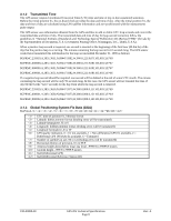
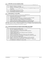
3.1.4 GPS DOP and Active Satellites (GSA) $GPGSA,,,,,,,,,,,,,,,,,*hh Mode, M = Manual, A = Automatic Fix type, 1 = not available, 2 = 2D, 3 = 3D PRN number, 01 to 32, of satellite used in solution, up to 12 transmitted (leading zeros will be transmitted) Position dilution of precision, 0.5 to 99.9 Horizontal dilution of precision, 0.5 to 99.9 Vertical dilution of precision, 0.5 to 99.9 3.1.5 GPS Satellites in View (GSV) $GPGSV,,,,,,,,...,,,*hh Total number of GSV sentences to be transmitted Number of current GSV sentence Total number of satellites in view, 00 to 12 (leading zeros will be transmitted) Satellite PRN number, 01 to 32 (leading zeros will be transmitted) Satellite elevation, 00 to 90 degrees (leading zeros will be transmitted) Satellite azimuth, 000 to 359 degrees, true (leading zeros will be transmitted) Signal to noise ratio (C/No) 00 to 99 dB (leading zeros will be transmitted) Note: Items ,,, and repeat for each satellite in view to a maximum of four (4) satellites per sentence. GSV will be repeated as necessary to output all satellites in view (up to 12 satellites). Unused satellite fields will be truncated when less than four satellites are in the last GSV sentence. 3.1.6 Recommended Minimum Specific GPS/TRANSIT Data (RMC) $GPRMC,,,,,,,,,,,,*hh UTC time of position fix, hhmmss format Status, A = Valid position, V = NAV receiver warning Latitude, ddmm.mmmm format (leading zeros must be transmitted) Latitude hemisphere, N or S Longitude, dddmm.mmmm format (leading zeros must be transmitted) Longitude hemisphere, E or W Speed over ground: 000.0 to 999.9 knots (leading zeros will be transmitted) Course over ground, 000.0 to 359.9 degrees, true (leading zeros will be transmitted) UTC date of position fix, ddmmyy format Magnetic variation, 000.0 to 180.0 degrees (leading zeros will be transmitted) Magnetic variation direction, E or W (westerly variation adds to true course) Mode indicator (only output if NMEA 0183 version 2.30 active), A = Autonomous, D = Differential, E = Estimated, N = Data not valid 190-00880-00 GPS 20x Technical Specifications Page 9 Rev. A
-
 1
1 -
2
-
3
-
4
-
5
-
6
-
 7
7 -
 8
8 -
 9
9 -
 10
10 -
 11
11 -
 12
12 -
 13
13 -
 14
14 -
 15
15 -
 16
16 -
 17
17 -
18
-
19
 |
 |
