Garmin GMR 24 xHD Radome Installation Instructions - Page 1
Garmin GMR 24 xHD Radome Manual
 |
View all Garmin GMR 24 xHD Radome manuals
Add to My Manuals
Save this manual to your list of manuals |
Page 1 highlights
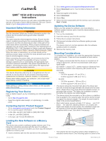
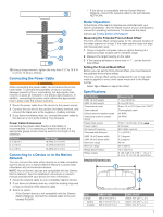
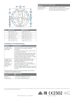
GMR™ 18/24 xHD Installation Instructions You can operate this device only with radar-compatible Garmin® devices or through a Garmin Marine Network. See your Garmin dealer or go to www.garmin.com for more details. Important Safety Information WARNING See the Important Safety and Product Information guide in the product box for product warnings and other important information. The radar transmits electromagnetic energy. Ensure that the radar is installed according to the recommendations in these instructions and that all personnel are clear of the path of the radar beam before transmitting. When properly installed and operated, the use of this radar conforms to the requirements of ANSI/IEEE C95. 1-1992 Standard for Safety Levels with Respect to Human Exposure to Radio Frequency Electromagnetic Fields. When the radar is transmitting, do not look directly at the antenna at close range; eyes are the most sensitive part of the body to electromagnetic energy. When connecting the power cable, do not remove the in-line fuse holder. To prevent the possibility of injury or product damage caused by fire or overheating, the appropriate fuse must be in place as indicated in the product specifications. In addition, connecting the power cable without the appropriate fuse in place voids the product warranty. CAUTION This device should be used only as a navigational aid. Do not attempt to use the device for any purpose requiring precise measurement of direction, distance, location, or topography. Always wear safety goggles, ear protection, and a dust mask when drilling, cutting, or sanding. NOTICE When drilling or cutting, always check what is on the opposite side of the surface. Registering Your Device Help us better support you by completing our online registration today. • Go to http: / / my .garmin .com. • Keep the original sales receipt, or a photocopy, in a safe place. Contacting Garmin Product Support • Go to www.garmin.com/ support and click Contact Support for in-country support information. • In the USA, call (913) 397. 8200 or (800) 800. 1020. • In the UK, call 0808 2380000. • In Europe, call +44 (0) 870. 8501241. 2 Go to www.garmin.com/ support / software / marine .html. 3 Select Download next to "Garmin Marine Network with SD card. " 4 Read and agree to the terms. 5 Select Download. 6 Select Run. 7 Select the drive associated with the memory card, and select Next > Finish. Updating the Device Software Before you can update the software, you must obtain a software-update memory card or load the latest software onto a memory card. 1 Turn on the chartplotter. 2 Insert the memory card into the card slot. 3 Follow the on-screen instructions. 4 Wait several minutes while the software update process completes. The device returns to normal operation after the software update process is complete. 5 Remove the memory card. Mounting Considerations To complete the installation, you need the appropriate fasteners, tools, and mounts. These items are available at most marine dealers. • It is highly recommended that the device is mounted out of range of personnel, with the horizontal beam width above head height. IEC 60936-1, clause 3-27. 1, states maximum distances from the antenna at which radio frequency (RF) levels can be expected: ◦ 18 xHD ◦ 100 W/m squared = 91 cm (36 in. ) ◦ 10 W/m squared = 289 cm (114 in. ) ◦ 24 xHD ◦ 100 W/m squared = 108 cm (43 in. ) ◦ 10 W/m squared = 343 cm (135 in. ) • The device should be mounted high above the ship's keel line with minimal blockage between the vessel and the radar beam. Obstructions may cause blind and shadow sectors, or generate false echoes. The higher the installation position, the farther the radome can detect targets. • The device should be mounted on a flat surface or a platform that is parallel to the vessel's water line and is sturdy enough to support the device's weight. The weight for each model is listed in the product specifications. • Most radar beams spread vertically 12. 5° above À and 12. 5° below Á the radome's radiating element. On vessels with higher bow angles at cruise speed, the installation angle can be lowered to point the beam slightly downward to the waterline while at rest. Use shims if necessary. Loading the New Software on a Memory Card The device may contain a software-update memory card. If so, follow the instructions provided with the card. If a software update memory card is not included, you must copy the software update to a memory card. 1 Insert a memory card into the card slot on the computer. • The radome has two mounting options when installed on a standard marine mount. One mounting option is closer to the January 2015 Printed in Taiwan 190-01656-02_0D
-
 1
1 -
 2
2 -
 3
3 -
 4
4
 |
 |