Garmin GTN 650 STC GTN 6XX/7XX Sample AFMS (DOC file) - Page 3
Determining When A Wfde Prediction Is Required - how to use the
 |
View all Garmin GTN 650 manuals
Add to My Manuals
Save this manual to your list of manuals |
Page 3 highlights
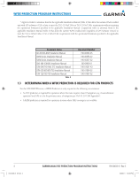
WFDE Prediction program INSTRUCTIONS 1.2 Determining When a WFDE Prediction is Required The WFDE Prediction Program determines whether the GPS constellation is robust enough to provide a navigation solution for the specified route of flight. As required (dependent upon type of flight plan, GPS Software (SW) version, and GPS antenna), prior to departure the operator must use the WFDE Prediction Program supplied with the applicable trainer or route planning software to demonstrate that there are no outages in the capability to navigate on the specified route of flight (Table 1). NOTE: If the route of flight requires an alternate airport, multiple predictions may be required (one for the primary and one for the alternate) to verify RAIM and/or WAAS satellite availability at the primary and the alternate approach. A WFDE Prediction is required for the following instances (see also Table 1): • For all Garmin WAAS enabled units (regardless of the GPS software version or antenna model): an FDE prediction is required for operations where the route requires Class II Navigation (e.g. Oceanic/Remote operation) and GPS is to be the primary source of navigation per FAA AC 20-138A Appendix 1. The Oceanic/Remote flight phase occurs when the flight plan will place the aircraft more than 200 nautical miles from the nearest airport. All operators using a Garmin WAAS-certified unit as primary means of navigation in oceanic/remote areas under FAR parts 91, 121, 125, and 135 must utilize the WFDE Prediction Program prior to conducting a flight in these areas. • For all Garmin WAAS enabled units (regardless of the GPS software version or antenna model): a RAIM prediction is required for operations in areas where SBAS coverage is not available. • For Garmin WAAS enabled units using an unapproved* GPS antenna (regardless of the GPS software version): a RAIM prediction is required for all flight operations in accordance with the National Aviation Authority guidelines for TSOC129a equipment. Examples of such operations include navigation of U.S. Area Navigation (RNAV) routes, Standard Instrument Departures (SIDs), or Standard Terminal Arrival Routes (STARs) per FAA AC 90-100A "U.S. Terminal and En Route Area Navigation (RNAV) Operations". • For Garmin WAAS enabled units using an unapproved* GPS antenna (regardless of the GPS software version): an operational limitation in the form of a WAAS satellite visibility prediction is required for all LNAV/VNAV, LP, or LPV approaches. • For Garmin WAAS enabled units with GPS Software v2.XX or earlier (regardless of GPS antenna model): an operational limitation in the form of a WAAS satellite visibility prediction is required for all LNAV/VNAV, LP, or LPV approaches. A WFDE Prediction is not required for the following instances (see also Table 1): • For Garmin WAAS enabled units with GPS Software v3.XX or later and using an approved* GPS antenna: a RAIM prediction is not required when operating in areas where SBAS coverage is available. • For Garmin WAAS enabled units with GPS Software v3.XX or later and using an approved* GPS antenna: a WAAS satellite visibility prediction is not required for LNAV/VNAV, LP, or LPV approaches. Route Type Oceanic/Remote Enroute/Terminal LNAV/VNAV, LP, or LPV Approach Oceanic/Remote Enroute/Terminal Enroute/Terminal LNAV/VNAV, LP, or LPV Approach LNAV/VNAV, LP, or LPV Approach Operations outside SBAS coverage GPS SW Version Antenna Type* 2.XX or earlier Approved/Unapproved 2.XX or earlier Approved/Unapproved 2.XX or earlier Approved/Unapproved 3.XX or later Approved/Unapproved 3.XX or later Approved 3.XX or later Unapproved 3.XX or later Approved 3.XX or later Unapproved All versions Approved/Unapproved Table 1 WFDE Prediction Required? YES YES YES YES NO YES NO YES YES 190-00643-01 Rev. E 190-00643-01_0E.indd 3 GARMIN WAAS FDE PREDICTION PROGRAM INSTRUCTIONS 3 2/28/2011 1:24:33 PM
-
 1
1 -
 2
2 -
 3
3 -
 4
4 -
 5
5 -
 6
6 -
 7
7 -
 8
8 -
 9
9 -
10
-
11
-
12
-
13
-
14
-
15
-
16
-
17
-
18
-
19
-
20
 |
 |