Garmin aera 510 Aviation Quick Reference Guide - Page 24
User Waypoints, Creating user waypoints
 |
View all Garmin aera 510 manuals
Add to My Manuals
Save this manual to your list of manuals |
Page 24 highlights
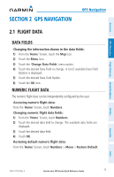
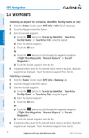
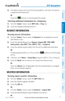
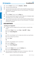
GPS Navigation Overview GPS Navigation Hazard Avoidance Flight Planning 1) From the 'Home' Screen, touch the Weather > METAR. 2) Touch the desired METAR flag. 3) Touch the Map Feature Button with the desired identifier displayed (refer to 'Map Panning' in the Overview Section for more information). The weather information is displayed. Or: 1) From the 'Home' Screen, touch the Map Icon. 2) Touch the desired METAR Flag (If the METAR flags are not displayed, adjust the settings from the 'Set Up Map' menu option). 3) Touch the Map Feature Button with the desired identifier displayed (refer to 'Map Panning' in the Overview Section for more information). The weather information is displayed. User Waypoints Creating user waypoints: 1) To create a new user waypoint at the current location or using the Map Pointer: a) From the 'Home' Screen, touch Tools > User WPT > Menu. b) Touch 'Create Waypoint'. Or: a) With a map displayed, touch an empty area without any map features. b) Touch the Map Feature Button. c) Touch 'Save'. Or: a) With a map displayed, touch a map feature. b) Touch the Menu Icon. c) Touch 'Create Waypoint'. Or: a) From the 'Home' Screen, touch the Position Icon. b) Touch the Mark Waypoint Button. 2) Enter the desired user waypoint name (up to 10 characters). Refer to the Overview Section on 'Data Entry' for more information. 18 Garmin aera 500 Series Quick Reference Guide 190-01117-03 Rev. A Utilities Appendix Index
-
 1
1 -
2
-
3
-
4
-
5
-
6
-
7
-
8
-
9
-
10
-
11
-
12
-
13
-
14
-
15
-
16
-
17
-
18
-
 19
19 -
 20
20 -
 21
21 -
 22
22 -
 23
23 -
 24
24 -
 25
25 -
 26
26 -
 27
27 -
 28
28 -
 29
29 -
30
-
31
-
32
-
33
-
34
-
35
-
36
-
37
-
38
-
39
-
40
-
41
-
42
-
43
-
44
-
45
-
46
-
47
-
48
 |
 |
