Magellan SporTrak Color User Manual - Page 49
Selecting Waypoints Nearest to the Cursor., Saving Present Position as a Waypoint, Creating New
 |
UPC - 763357105629
View all Magellan SporTrak Color manuals
Add to My Manuals
Save this manual to your list of manuals |
Page 49 highlights
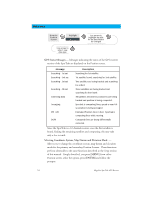
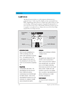
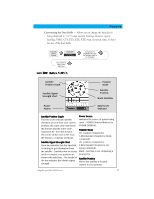
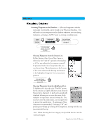
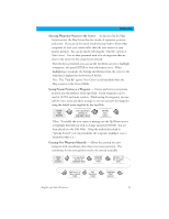
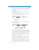
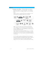
Reference Selecting Waypoints Nearest to the Cursor. As discussed in the Map Screen section, the Map Screen has two modes of operation, position and cursor. If you are in the cursor mode you may want to know what waypoints are near your cursor rather than the ones nearest to your present position. You can do this by selecting the "Find By" option of Near Cursor. You are then presented with a list of waypoints that are close to the cursor for the category you selected. After the list is presented, you can use the Up/Down arrows to highlight a waypoint, and press ENTER to view information on it. When highlighting a waypoint, the bearing and distance from the cursor to the waypoint is displayed at the bottom of the list. Note: The "Find By" option Near Cursor is only available when the Map screen is in the Cursor Mode. Saving Present Position as a Waypoint - Creates and stores your present position into the memory of the SporTrak. Stored waypoints can be used in GOTO and route creation. While saving the waypoint, you can edit the icon, name and add a message or you can just save the waypoint using the default name supplied by the SporTrak. From Any Screen Use up/down arrows to highlight Mark Modify (see Note) (Note: To modify the icon, name or message use the Up/Down arrows to highlight the field you wish to change and press ENTER. You are then placed into the Edit Mode. Using the method described in "Getting Started" you can personalize the waypoint, making it easy to remember what it is.) Creating New Waypoint Manually - Allows the creation of a new waypoint with coordinates other than your present position. The coordinates for the new position need to be entered manually. From Any Screen Use up/down arrows to highlight Mark Highlight Location Field Edit Line 1 of the Location Field Edit Line 2 of the Location Field Edit Elevation Field Highlight "Save" Button Magellan SporTrak GPS Receiver 39
-
 1
1 -
2
-
3
-
4
-
5
-
6
-
7
-
8
-
9
-
10
-
11
-
12
-
13
-
14
-
15
-
16
-
17
-
18
-
19
-
20
-
21
-
22
-
23
-
24
-
25
-
26
-
27
-
28
-
29
-
30
-
31
-
32
-
33
-
34
-
35
-
36
-
37
-
38
-
39
-
40
-
41
-
42
-
43
-
 44
44 -
 45
45 -
 46
46 -
 47
47 -
 48
48 -
 49
49 -
 50
50 -
 51
51 -
 52
52 -
 53
53 -
 54
54 -
55
-
56
-
57
-
58
-
59
-
60
-
61
-
62
-
63
-
64
-
65
-
66
-
67
-
68
-
69
-
70
-
71
-
72
-
73
-
74
-
75
-
76
-
77
-
78
-
79
-
80
-
81
-
82
-
83
-
84
-
85
-
86
 |
 |