Magellan Triton 400 Manual - English - Page 11
Specifications, Latitude/Longitude, UTM, OSGB, Irish, Swish, Finnish, German - gps receiver
 |
UPC - 763357117769
View all Magellan Triton 400 manuals
Add to My Manuals
Save this manual to your list of manuals |
Page 11 highlights
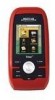
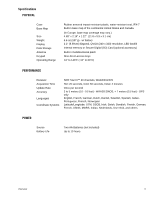
Specifications PHYSICAL Case Base Map Size Weight Display Data Storage Antenna Keypad Operating Range Rubber armored impact-resistant plastic, water-resistant seal, IPX-7 Built-in base map of the continental United States and Canada. (In Europe, base map coverage may vary.) 4.65" x 2.16" x 1.22" (11.8 x 5.5 x 3.1 cm) 6.6 oz (187 g) - w/ battery 2.2" (5.59cm) diagonal, QVGA (240 x 320) resolution, LED backlit Internal memory or Secure Digital (SD) Card (optional accessory) Built-in multidirectional patch Nine direct-access keys 14° to 140°F (-10° to 60°C) PERFORMANCE Receiver Acquisition Time Update Rate Accuracy Languages Coordinate Systems SiRF Star III™ 20 channels, WAAS/EGNOS Hot: 20 seconds, Cold: 60 seconds, Initial: 2 minutes Once per second 3 to 5 meters (10 - 16 feet) - WAAS/EGNOS, < 7 meters (15 feet) - GPS only English, French, German, Dutch, Danish, Swedish, Spanish, Italian, Portuguese, Finnish, Norwegian Latitude/Longitude, UTM, OSGB, Irish, Swish, Swedish, Finnish, German, French, USNG, MGRS, Indian, Nederlands, User Grid, and others. POWER Source Battery Life Two AA Batteries (not included) Up to 10 hours Overview 3
-
 1
1 -
2
-
3
-
4
-
5
-
 6
6 -
 7
7 -
 8
8 -
 9
9 -
 10
10 -
 11
11 -
 12
12 -
 13
13 -
 14
14 -
 15
15 -
 16
16 -
17
-
18
-
19
-
20
-
21
-
22
-
23
-
24
-
25
-
26
-
27
-
28
-
29
-
30
-
31
-
32
-
33
-
34
-
35
-
36
-
37
-
38
-
39
-
40
-
41
-
42
-
43
-
44
-
45
-
46
-
47
-
48
-
49
-
50
-
51
-
52
-
53
-
54
-
55
-
56
-
57
-
58
-
59
-
60
-
61
-
62
-
63
-
64
-
65
 |
 |
