2011 Chrysler 300 UConnect Manual - Page 90
2011 Chrysler 300 Manual

Page 90 highlights
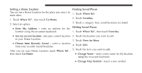
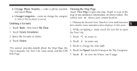
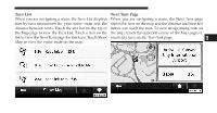
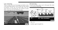
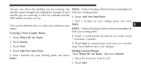
Uconnect Touch™ 8.4 SYSTEM 89 The sky view shows the satellites you are receiving. The NOTE: Perform Finding a Point of Interest procedure to satellite signal-strength bars indicate the strength of each find your starting point. satellite you are receiving. A solid bar indicates that the 6. Touch Add New Start Point. GPS satellite is ready for use. 7. Find a location for your ending point, and touch Creating and Editing Routes Select. This section describes how to create and customize your NOTE: Perform Finding a Point of Interest procedure to routes. find your ending point. Creating a New Custom Route 8. Touch + to add another location to your route. Touch 1. Touch Where To? (or Tools). - to remove a location. 2. Touch Routes. 9. Touch Next to calculate your route and view it on the 3. Touch New. map. Touch Save to save your changes. 4. Touch Add New Start Point. Editing Custom Routes Touch Where To? (or Tools) , then touch Routes. 3 5. Find a location for your starting point, and touch 1. Select the route you want to edit. Select. 2. Touch Edit.
-
 1
1 -
2
-
3
-
4
-
5
-
6
-
7
-
8
-
9
-
10
-
11
-
12
-
13
-
14
-
15
-
16
-
17
-
18
-
19
-
20
-
21
-
22
-
23
-
24
-
25
-
26
-
27
-
28
-
29
-
30
-
31
-
32
-
33
-
34
-
35
-
36
-
37
-
38
-
39
-
40
-
41
-
42
-
43
-
44
-
45
-
46
-
47
-
48
-
49
-
50
-
51
-
52
-
53
-
54
-
55
-
56
-
57
-
58
-
59
-
60
-
61
-
62
-
63
-
64
-
65
-
66
-
67
-
68
-
69
-
70
-
71
-
72
-
73
-
74
-
75
-
76
-
77
-
78
-
79
-
80
-
81
-
82
-
83
-
84
-
 85
85 -
 86
86 -
 87
87 -
 88
88 -
 89
89 -
 90
90 -
 91
91 -
 92
92 -
 93
93 -
 94
94 -
 95
95 -
96
-
97
-
98
-
99
-
100
-
101
-
102
-
103
-
104
-
105
-
106
-
107
-
108
-
109
-
110
-
111
-
112
-
113
-
114
-
115
-
116
-
117
-
118
-
119
 |
 |
