2007 Lexus SC 430 Navigation Manual - Page 9
2007 Lexus SC 430 Manual

Page 9 highlights
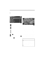
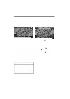
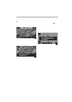
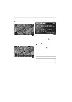
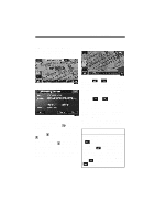
BASIC FUNCTIONS 9 MEMORY POINT INFORMATION When the cursor is set on a memory point icon, the name and "Info." switch are displayed on the top of screen. Map scale Touch the "Info." switch. Touch the or switch to change the scale of the map display. The scale bar and indicator at the bottom of the screen indicates the map scale menu. The scale ranges 150 feet (50 m) to 250 miles (400 km). or switch until the Touch the scale bar changes normally. If you continue to touch on the switch, the scale bar changes smoothly. You can change the scale of the map display by touching the scale bar directly. It is not available during driving. The map scale is displayed under the north-up symbol or heading-up symbol at the top left of the screen. 1U018a Information such as the name, location, and phone number are displayed. If you touch the "Enter " switch, the position of cursor is set as a destination. If there is already a set destination, the "Add to " switch and the "Replace " switch are displayed. When there is already a preset destination, using the "Add to " switch to set an additional destination, will set the new one as the first point of arrival. To edit a memory point, touch the "Edit" switch. (For details, see page 90.) INFORMATION When the map scale is at the maximum range of 250 miles (400 km), is not shown. When the map scale is at the minimum range of 150 feet (50 m), is not shown. However, in the area where the foot print map is contained, when the map scale is changed to 150 feet (50 m), the switch changes to the switch.
-
 1
1 -
2
-
3
-
 4
4 -
 5
5 -
 6
6 -
 7
7 -
 8
8 -
 9
9 -
 10
10 -
 11
11 -
 12
12 -
 13
13 -
 14
14 -
15
-
16
-
17
-
18
-
19
-
20
-
21
-
22
-
23
-
24
-
25
-
26
-
27
-
28
-
29
-
30
-
31
-
32
-
33
-
34
-
35
-
36
-
37
-
38
-
39
-
40
-
41
-
42
-
43
-
44
-
45
-
46
-
47
-
48
-
49
-
50
-
51
-
52
-
53
-
54
-
55
-
56
-
57
-
58
-
59
-
60
-
61
-
62
-
63
-
64
-
65
-
66
-
67
-
68
-
69
-
70
-
71
-
72
-
73
-
74
-
75
-
76
-
77
-
78
-
79
-
80
-
81
-
82
-
83
-
84
-
85
-
86
-
87
-
88
-
89
-
90
-
91
-
92
-
93
-
94
-
95
-
96
-
97
-
98
-
99
-
100
-
101
-
102
-
103
-
104
-
105
-
106
-
107
-
108
-
109
-
110
-
111
-
112
-
113
-
114
-
115
-
116
-
117
-
118
-
119
-
120
-
121
-
122
-
123
-
124
-
125
-
126
-
127
-
128
-
129
-
130
-
131
-
132
-
133
-
134
-
135
-
136
-
137
-
138
-
139
-
140
-
141
-
142
-
143
-
144
-
145
-
146
-
147
-
148
-
149
-
150
-
151
-
152
-
153
-
154
-
155
-
156
-
157
-
158
-
159
-
160
-
161
-
162
-
163
-
164
-
165
-
166
-
167
-
168
-
169
-
170
-
171
-
172
-
173
-
174
 |
 |
