Audiovox NAV101 Operation Manual - Page 4
Parts List, About GPS and GNSS - module
 |
UPC - 043258304056
View all Audiovox NAV101 manuals
Add to My Manuals
Save this manual to your list of manuals |
Page 4 highlights
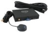
Parts List • NAV101 navigation module • SIRF III Antenna with magnetic mount • Left and right mounting brackets • Four rubber feet (to affix to the bottom of the NAV101 in the recessed area near each corner) • SmartBus cable (used to connect the NAV101 to the Audiovox navigation-ready radio) • Four 6mm (.25in) screws (to secure the left and right mounting brackets to the NAV101 navigation module) • One 2 Gigabyte SD Card pre loaded with map/navigation software • Two 11mm (.4in) screws (for fastening the SmartBus cable to the radio and NAV101) • DVD with backup software for map data and navigation About GPS and GNSS The NAV101 is a vehicle GPS (Global Positioning Satellite)-based navigation device which utilizes digital map data to guide you from your selected location A to location B, using location information obtained from a Global Navigation Satellite System (GNSS). A GNSS consists of a set of satellites that transmit high-frequency radio signals containing time, direction, and distance data that can be picked up by a receiver, allowing users to pinpoint their precise locations anywhere around the globe. Navigation Satellite Receivers (GPS devices) use this transmitted information to calculate an exact location on the earth. Every point on Earth can be identified by latitude and longitude. The receiver uses the information sent by at least three satellites and determines the coordinates of the receiving device. By comparing the time the signals were transmitted from the satellites and the time they were recorded, the receiver calculates how far away each satellite is. The distance of the receiver from three or more satellites reflects its position on the surface of the planet. Using these distance measurements, the receiver might also be able to calculate speed, bearing, trip time, distance to destination, altitude, etc. The GPS position may be displayed as a point on a digital map (at least three satellites' signals must be received) and as the GPS device moves the corresponding trace is displayed as well. 4 Subject to technical change
-
 1
1 -
 2
2 -
 3
3 -
 4
4 -
 5
5 -
 6
6 -
 7
7 -
 8
8 -
 9
9 -
 10
10 -
11
-
12
-
13
-
14
-
15
-
16
-
17
-
18
-
19
-
20
-
21
-
22
-
23
-
24
-
25
-
26
-
27
-
28
-
29
-
30
-
31
-
32
-
33
-
34
-
35
-
36
-
37
 |
 |
