Garmin GPSMAP 3210 Owner's Manual - Page 91
General Sub Tab, Automatic Scroll Speed Limit
 |
UPC - 753759053062
View all Garmin GPSMAP 3210 manuals
Add to My Manuals
Save this manual to your list of manuals |
Page 91 highlights
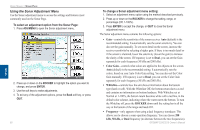
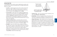
General Sub Tab Use the General sub tab to select the water type, depth number, automatic scroll speed limit, scale, keel offset, and transducer type. The available General sub tab options are as follows: • Auto Gain-controls the aggressiveness of the Auto Gain when the Gain option is set to Auto. The higher the setting, the greater the number of targets appear on the screen. The lower the setting, the less clutter on the screen. The settings are Low, Medium (default), and High. • Auto Color Gain-controls what colors are applied to the objects on the screen when the Color Gain option is set to Auto. Color DCG™ is based on depth and makes it easier to spot subtle changes in bottom conditions or fish sizes. DynaColor™ (default) represents the latest in sonar data presentation and is recommended for all applications. The presentation is based on bottom strength. It makes the bottom and the fish easier to see and requires fewer adjustments. • Automatic Scroll Speed Limit-automatically adjusts the Scroll rate with the speed of your vessel. Enter your maximum cruising speed, and the scroll rate adjusts to 100% when you reach that speed. One half of that speed produces a 50% scroll rate, and so on. The default is 30.0 kt. • Keel Offset-allows you to offset the surface reading for the depth of a keel. This makes it possible to measure depth from the bottom of your keel instead of from a transducer's location near the water line. Enter a positive number to offset for a keel. You can also enter a negative number to compensate for a large vessel that may draw several feet of water, requiring the transducer to be submerged if you want to measure from the water line. The Keel Offset is reflected in the depth reading. Transducer at surface. Enter (+) a positive number to show depth from bottom of keel. Using Sonar > Sonar Tab Transducer at bottom of keel. Enter (-) a negative number to show depth from surface. • Transducer Type-allows you to specify what type of transducer you are using, either Dual Beam or Dual Frequency. • Custom Range-allows you to specify a custom viewing range or scale. When On, this range appears as Custom in the Range setting. The left value is the top of the scale and the right value is the bottom of the scale. • Calibrate Water Speed-this is available only if you are using a speedcapable transducer/sensor. Calibration is required to ensure that the Water Speed shown on your unit is accurate. The unit automatically uses the GPS ground speed, if it is available, for comparison on the calibration. If a GPS ground speed is not available, use either your boat's speedometer reading (not always accurate) or a stopwatch to determine your speed over a certain distance (distance / time = speed). It is recommended that you calibrate in water having little or no current. Sonar GPSMAP 3206/3210 Owner's Manual 83
-
 1
1 -
2
-
3
-
4
-
5
-
6
-
7
-
8
-
9
-
10
-
11
-
12
-
13
-
14
-
15
-
16
-
17
-
18
-
19
-
20
-
21
-
22
-
23
-
24
-
25
-
26
-
27
-
28
-
29
-
30
-
31
-
32
-
33
-
34
-
35
-
36
-
37
-
38
-
39
-
40
-
41
-
42
-
43
-
44
-
45
-
46
-
47
-
48
-
49
-
50
-
51
-
52
-
53
-
54
-
55
-
56
-
57
-
58
-
59
-
60
-
61
-
62
-
63
-
64
-
65
-
66
-
67
-
68
-
69
-
70
-
71
-
72
-
73
-
74
-
75
-
76
-
77
-
78
-
79
-
80
-
81
-
82
-
83
-
84
-
85
-
 86
86 -
 87
87 -
 88
88 -
 89
89 -
 90
90 -
 91
91 -
 92
92 -
 93
93 -
 94
94 -
 95
95 -
 96
96 -
97
-
98
-
99
-
100
-
101
-
102
-
103
-
104
-
105
-
106
-
107
-
108
-
109
-
110
-
111
-
112
-
113
-
114
-
115
-
116
-
117
-
118
-
119
-
120
-
121
-
122
-
123
-
124
-
125
-
126
-
127
-
128
-
129
-
130
 |
 |
