Garmin GPSMAP 64s Quick Start Manual - Page 4
Device Information - gpsmap 64st manual
 |
View all Garmin GPSMAP 64s manuals
Add to My Manuals
Save this manual to your list of manuals |
Page 4 highlights
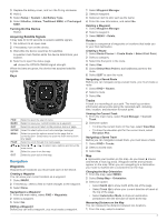
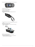
2 Select MENU > Measure Distance. 3 Move the pin to another location on the map. Compass When navigating, points to your destination, regardless of the direction you are moving. When points toward the top of the electronic compass, you are traveling directly toward your destination. If points any other direction, turn until it points toward the top of the compass. Calibrating the Compass Before you can calibrate the electronic compass, you must be outdoors, away from objects that influence magnetic fields, such as cars, buildings, or overhead power lines. The device has a 3-axis electronic compass (GPSMAP 64s and GPSMAP 64st models only). You should calibrate the compass after moving long distances, experiencing temperature changes, or changing the batteries. 1 From the compass, select MENU. 2 Select Calibrate Compass > Start. 3 Follow the on-screen instructions. Navigating with Sight 'N Go You can point the device at an object in the distance, lock in the direction, and navigate to the object. NOTE: Sight 'N Go is available only on the GPSMAP 64s and GPSMAP 64st. 1 Select Sight 'N Go. 2 Point the device at an object. 3 Select Lock Direction > Set Course. 4 Navigate using the compass. Trip Computer The trip computer displays your current speed, average speed, maximum speed, trip odometer, and other helpful statistics. You can customize the trip computer layout, dashboard, and data fields. Device Information Specifications Battery type Battery life Water resistance Operating temperature range Charging temperature range Radio frequency and protocols Compass-safe distance NiMH battery pack or two AA batteries (1. 5 V or lower alkaline, NiMH, or lithium) Up to 16 hours IEC 60529 IPX7 From -4° to 158°F (from -20° to 70°C) From 32° to 104°F (from 0° to 40°C) 2. 4 GHz ANT+; Bluetooth® 4. 0 (includes EDR and BLE) 7 in. (17. 5 cm) Calibrating the Barometric Altimeter You can manually calibrate the barometric altimeter if you know the correct elevation or the correct barometric pressure. NOTE: The barometric altimeter is available only on the GPSMAP 64s and GPSMAP 64st. 1 Go to a location where the elevation or barometric pressure is known. 2 Select PAGE > Elevation Plot > MENU > Calibrate Altimeter. 3 Follow the on-screen instructions. Customizing the Data Fields You can customize the data fields displayed on each main page. 1 Open the page for which you will change the data fields. 2 Select MENU. 3 Select Change Data Fields. 4 Select the new data field. 5 Follow the on-screen instructions. Support and Updates Garmin Express™ provides easy access to these services for Garmin devices. Some services may not be available for your device. • Product registration • Product manuals • Software updates • Map updates • Vehicles, voices, and other extras Setting Up Garmin Express 1 Plug the small end of the USB cable into the port on the device. 2 Plug the larger end of the USB cable into an available USB port on your computer. 3 Go to www.garmin.com/ express. 4 Follow the on-screen instructions. Getting More Information You can find more information about this product on the Garmin website. • Go to www.garmin.com/ outdoor. • Go to www.garmin.com/ learningcenter. • Go to http: / / buy .garmin .com, or contact your Garmin dealer for information about optional accessories and replacement parts. Getting the Owner's Manual You can get the latest owner's manual from the web. 1 Go to www.garmin.com/ support. 2 Select Manuals. 3 Follow the on-screen instructions to select your product. Adjusting the Backlight Brightness Extensive use of screen backlighting can significantly reduce battery life. You can adjust the backlight brightness to maximize the battery life. NOTE: The backlight brightness may be limited when the battery is low. 1 Select . 2 Use the slider to adjust the backlight level. The device may feel warm when the backlight setting is high. Selecting the Battery Type 1 From the main menu, select Setup > System > AA Battery Type. 2 Select Alkaline, Lithium, Traditional NiMH, or Precharged NiMH. Installing a Memory Card WARNING Do not use a sharp object to remove user-replaceable batteries. You can install a microSD memory card in the handheld device for additional storage or pre-loaded maps. 1 Turn the D-ring counter-clockwise, and pull up to remove the cover. 2 Remove the battery. 3 Slide the card holder À to and lift up. 4
-
 1
1 -
 2
2 -
 3
3 -
 4
4 -
 5
5 -
 6
6
 |
 |