Garmin GPSMAP 64x Owners Manual - Page 13
System Settings, Display Settings
 |
View all Garmin GPSMAP 64x manuals
Add to My Manuals
Save this manual to your list of manuals |
Page 13 highlights
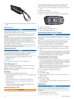
Pointer: An arrow points in the direction of the next waypoint or turn. You must be navigating for this data to appear. Speed: The current rate of travel. Speed Limit: The reported speed limit for the road. Not available in all maps and in all areas. Always rely on posted road signs for actual speed limits. Speed - Maximum: The highest speed reached since the last reset. Speed - Moving Avg.: The average speed while moving since the last reset. Speed - Overall Avg.: The average speed while moving and stopped since the last reset. Stopwatch Timer: The stopwatch time for the current activity. Sunrise: The time of sunrise based on your GPS position. Sunset: The time of sunset based on your GPS position. Temperature: The temperature of the air. Your body temperature affects the temperature sensor. Your device must be connected to a wireless temperature sensor for this data to appear. Temperature - Water: The temperature of the water. Your device must be connected to a NMEA 0183 device capable of acquiring the water temperature. Time of Day: The current time of day based on your current location and time settings (format, time zone, daylight saving time). Time To Destination: The estimated time remaining before you reach the destination. You must be navigating for this data to appear. Time To Next: The estimated time remaining before you reach the next waypoint in the route. You must be navigating for this data to appear. To Course: The direction in which you must move to get back on the route. You must be navigating for this data to appear. Total Lap: The stopwatch time for all the completed laps. Track Distance: The distance traveled for the current track. Trip Odometer: A running tally of the distance traveled since the last reset. Trip Time: A running tally of the total time spent moving and not moving since the last reset. Trip Time - Moving: A running tally of the time spent moving since the last reset. Trip Time - Stopped: A running tally of the time spent not moving since the last reset. Turn: The angle of difference (in degrees) between the bearing to your destination and your current course. L means turn left. R means turn right. You must be navigating for this data to appear. Velocity Made Good: The speed at which you are closing on a destination along a route. You must be navigating for this data to appear. Vertical Dist to Dest: The elevation distance between your current position and the final destination. You must be navigating for this data to appear. Vertical Speed: The rate of ascent or descent over time. Vertical Speed To Dest: The rate of ascent or descent to a predetermined altitude. You must be navigating for this data to appear. Waypoint At Dest: The last point on the route to the destination. You must be navigating for this data to appear. Waypoint At Next: The next point on the route. You must be navigating for this data to appear. System Settings Select Setup > System. Satellite System: Sets the satellite system (GPS and Other Satellite Systems, page 9). WAAS/EGNOS: Enables the system to use Wide Area Augmentation System/European Geostationary Navigation Overlay Service (WAAS/EGNOS) data. Language: Sets the text language on the device. NOTE: Changing the text language does not change the language of user-entered data or map data, such as street names. Interface: Sets the format of the serial interface (Serial Interface Settings, page 9). AA Battery Type: Allows you to change the type of AA battery you are using. NOTE: This setting is disabled when the NiMH battery pack is installed. GPS and Other Satellite Systems Using GPS and another satellite system together offers increased performance in challenging environments and faster position acquisition than using GPS only. However, using multiple systems can reduce battery life more quickly than using GPS only. Your device can use these Global Navigation Satellite Systems (GNSS). Some satellite systems may not be available for all device models. GPS: A satellite constellation built by the United States. GLONASS: A satellite constellation built by Russia. GALILEO: A satellite constellation built by the European Space Agency. Serial Interface Settings Select Setup > System > Interface. Garmin Spanner: Allows you to use the device USB port with most NMEA 0183-compliant mapping programs by creating a virtual serial port. Garmin Serial: Sets the device to use a Garmin proprietary format to exchange waypoint, route, and track data with a computer. NMEA In/Out: Sets the device to use standard NMEA 0183 output and input. Text Out: Provides simple ASCII text output of location and velocity information. RTCM: Allows the device to accept Differential Global Positioning System (DGPS) information from a device supplying Radio Technical Commission for Maritime Services (RTCM) data in an SC-104 format. MTP: Sets the device to use Media Transfer Protocol (MTP) to access the file system on the device instead of mass storage mode. Display Settings Select Setup > Display. Backlight Timeout: Adjusts the length of time before the backlight turns off. Battery Save: Saves the battery power and prolongs the battery life by turning off the screen when the backlight times out. Colors: Changes the appearance of the display background and selection highlight. Main, Setup, Find Style: Changes the style of the menu system. Screen Capture: Allows you to save the image on the device screen. Customizing the Device 9
-
 1
1 -
2
-
3
-
4
-
5
-
6
-
7
-
 8
8 -
 9
9 -
 10
10 -
 11
11 -
 12
12 -
 13
13 -
 14
14 -
 15
15 -
 16
16 -
 17
17 -
 18
18 -
19
-
20
 |
 |