Garmin GPSMAP 8500 Black Box Installation Instructions - Page 11
Card Reader Connections, Appendix - head
 |
View all Garmin GPSMAP 8500 Black Box manuals
Add to My Manuals
Save this manual to your list of manuals |
Page 11 highlights
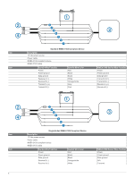
Card Reader Connections Connecting to Power WARNING When connecting the power cable, do not remove the in-line fuse holder. To prevent the possibility of injury or product damage caused by fire or overheating, the appropriate fuse must be in place as indicated in the product specifications. In addition, connecting the power cable without the appropriate fuse in place will void the product warranty. 1 Route the power cable to the power source and to the device. 2 Connect the red wire to the positive (+) battery terminal, and connect the black wire to the negative (-) battery terminal. 3 Install the locking ring and o-ring on the end of the power cable. 4 Connect the power cable to the device by turning the locking ring clockwise. Connecting the Card Reader to the Garmin Marine Network The card reader is not compatible with Garmin chartplotters prior to the GPSMAP 8000 Series and GPSMAP 8500. Connect the card reader to a Garmin device on the Garmin Marine Network using a Garmin Marine Network cable. Data from cards inserted in the card reader is shared with all compatible devices on the Garmin Marine Network. Appendix Specifications Physical Specifications Specification Measurement Dimensions (H×W×D) 1563/64 × 455/64 × 927/64in. (406 × 123. 5 × 239. 5 mm) Weight 10. 85 lbs (4. 92 kg) Temperature range From 5° to 131°F (from -15° to 55°C) Material Aluminum Power Specifications Measurement Input power Fuse Max. power usage at 10 Vdc Typical current draw at 12 Vdc Max. current draw at 12 Vdc NMEA 2000 LEN NMEA 2000 Draw Compass-safe distance Specification 10-35 Vdc 7. 5 A, 42 V fast-acting 17 W 0. 8 A 1. 7 A 2 75 mA max. 5½ in. (140 mm) NMEA 2000 PGN Information Type Transmit and receive PGN Description 059392 ISO acknowledgment 059904 ISO request 060928 ISO address claim 126208 NMEA: Command, request, and acknowledge group function 126464 Transmit and receive PGN list group function 126996 Product information 129026 COG and SOG: Rapid update 129029 GNSS position data Type Transmit Receive PGN Description 129540 GNSS satellites in view 130306 Wind data 130312 Temperature 127250 Vessel heading 127258 Magnetic variance 128259 Speed: Water referenced 128267 Water depth 129025 Position: Rapid update 129283 Cross track error 129284 Navigation data 129285 Navigation route and waypoint info 126992 System time 127250 Vessel heading 127489 Engine parameters: Dynamic 127488 Engine parameters: Rapid update 127493 Transmission parameters: Dynamic 127505 Fluid level 128259 Speed: Water referenced 128267 Water depth 129025 Position: Rapid update 129038 AIS class A position report 129039 AIS class B position report 129040 AIS class B extended position report 129539 GNSS DOPs 129794 AIS class A static and voyage related data 129809 AIS class B "CS" static data report, part A 129810 AIS class B "CS" static data report, part B 130310 Environmental parameters 130311 Environmental parameters (obsolete) 130313 Humidity 130314 Actual pressure NMEA 0183 Information Type Transmit Sentence GPAPB GPBOD GPBWC GPGGA GPGLL GPGSA GPGSV GPRMB GPRMC GPRTE GPVTG GPWPL GPXTE PGRME PGRMM Description APB: Heading or track controller (autopilot) sentence "B" BOD: Bearing (origin to destination) BWC: Bearing and distance to waypoint GGA: Global positioning system fix data GLL: Geographic position (latitude and longitude) GSA: GNSS DOP and active satellites GSV: GNSS satellites in view RMB: Recommended minimum navigation information RMC: Recommended minimum specific GNSS data RTE: Routes VTG: Course over ground and ground speed WPL: Waypoint location XTE: Cross track error E: Estimated error M: Map datum 11
-
 1
1 -
2
-
3
-
4
-
5
-
 6
6 -
 7
7 -
 8
8 -
 9
9 -
 10
10 -
 11
11 -
 12
12
 |
 |
