Garmin StreetPilot III Deluxe Owner's Manual - Page 3
Introduction - color gps streetpilot 3
 |
View all Garmin StreetPilot III Deluxe manuals
Add to My Manuals
Save this manual to your list of manuals |
Page 3 highlights
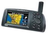
Welcome Thank you for choosing the Garmin StreetPilot III. The StreetPilot III offers true turn-by-turn navigation with its auto-routing feature. At the touch of a button, you now have access to the shortest and fastest routes, turn directions, and estimated time of arrival at your intended destination. Along the way, the StreetPilot III provides automated voice prompts, alerting you to necessary turns, distance to upcoming turns, route deviation, and distance to the final destination. The StreetPilot III is compact and portable. This dash-mounted unit can be operated by your vehicle's battery using the included 12-volt power adapter, or by six AA batteries. Voice commands are clearly heard through a speaker which is built into the power adapter cable. The StreetPilot III can easily be viewed in any lighting condition, due to its 4-inch, high resolution, 16-color display. The unit's built-in basemap provides detail for interstates, interstate exit data, highways, rivers and lakes, plus commonly used streets in metropolitan areas. With the press of a button, the built-in basemap will provide turn-by-turn guidance to a destination via interstates and highways. When a card with MapSource City Navigator maps is in the unit, the StreetPilot III provides turn-by-turn guidance down to residential street-level detail. About This Manual Make sure you take the time to read the Quick Reference Guide first to get acquainted with the basic features of the StreetPilot III. After you have read the Quick Reference Guide, you can read through this owner's manual in order to understand the operating features of the StreetPilot III in detail. This manual is organized into three sections for your convenience. The Introduction Section provides FCC and safety information and the table of contents. The Reference Section provides details about all of the features of the StreetPilot III, organized by topic. The Appendices contain both information on items such as accessories and specifications, and an index organized by subject. Introduction Welcome The StreetPilot III uses GPS technology in order to find your precise location. GPS stands for Global Positioning System, a group of 24 satellites, circling the earth twice a day, at an altitude of about 12,000 miles. The satellites transmit very low power radio signals containing position and time information, allowing anyone with a GPS receiver to determine their location on the earth within 100 meters or better. For more detailed information regarding GPS, we have prepared a booklet called "GPS Guide for Beginners" which is available to you from our web site at www.garmin.com. 1
-
 1
1 -
 2
2 -
 3
3 -
 4
4 -
 5
5 -
 6
6 -
 7
7 -
 8
8 -
 9
9 -
10
-
11
-
12
-
13
-
14
-
15
-
16
-
17
-
18
-
19
-
20
-
21
-
22
-
23
-
24
-
25
-
26
-
27
-
28
-
29
-
30
-
31
-
32
-
33
-
34
-
35
-
36
-
37
-
38
-
39
-
40
-
41
-
42
-
43
-
44
-
45
-
46
-
47
-
48
-
49
-
50
-
51
-
52
-
53
-
54
-
55
-
56
-
57
-
58
-
59
-
60
-
61
-
62
-
63
-
64
-
65
-
66
-
67
-
68
-
69
-
70
-
71
-
72
-
73
-
74
 |
 |
