Garmin aera 500 Pilot's Guide - Page 33
Map Overlays, Displaying/removing map overlays
 |
View all Garmin aera 500 manuals
Add to My Manuals
Save this manual to your list of manuals |
Page 33 highlights
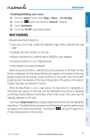
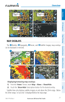
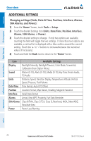
Overview GPS Navigation Flight Planning Hazard Avoidance Additional Features Overview ➊ ➋ ➌ ➍ Map Overlays The ➊Weather, ➋Topography, ➌Terrain, and ➍Satellite Imagery map overlays can be displayed or removed. ➊ ➋ ➌ ➍ Appendices Index Displaying/removing map overlays: 1) From the 'Home' Screen, touch Map > Menu > Show/Hide. 2) Touch the 'Show/Hide' Data Option Button for the desired overlay. Satellite View only displays satellite imagery at and above the 20nm range. Below the 20nm range, 'no sat view' is displayed below the map range. 190-01117-02 Rev. A Garmin aera 500 Series Pilot's Guide 21
-
 1
1 -
2
-
3
-
4
-
5
-
6
-
7
-
8
-
9
-
10
-
11
-
12
-
13
-
14
-
15
-
16
-
17
-
18
-
19
-
20
-
21
-
22
-
23
-
24
-
25
-
26
-
27
-
 28
28 -
 29
29 -
 30
30 -
 31
31 -
 32
32 -
 33
33 -
 34
34 -
 35
35 -
 36
36 -
 37
37 -
 38
38 -
39
-
40
-
41
-
42
-
43
-
44
-
45
-
46
-
47
-
48
-
49
-
50
-
51
-
52
-
53
-
54
-
55
-
56
-
57
-
58
-
59
-
60
-
61
-
62
-
63
-
64
-
65
-
66
-
67
-
68
-
69
-
70
-
71
-
72
-
73
-
74
-
75
-
76
-
77
-
78
-
79
-
80
-
81
-
82
-
83
-
84
-
85
-
86
-
87
-
88
-
89
-
90
-
91
-
92
-
93
-
94
-
95
-
96
-
97
-
98
-
99
-
100
-
101
-
102
-
103
-
104
-
105
-
106
-
107
-
108
-
109
-
110
-
111
-
112
-
113
-
114
-
115
-
116
-
117
-
118
-
119
-
120
-
121
-
122
-
123
-
124
-
125
-
126
-
127
-
128
-
129
-
130
-
131
-
132
-
133
-
134
-
135
-
136
-
137
-
138
-
139
-
140
-
141
-
142
-
143
-
144
-
145
-
146
-
147
-
148
-
149
-
150
-
151
-
152
-
153
-
154
-
155
-
156
-
157
-
158
-
159
-
160
-
161
-
162
-
163
-
164
-
165
-
166
-
167
-
168
-
169
-
170
-
171
-
172
-
173
-
174
-
175
-
176
-
177
-
178
-
179
-
180
-
181
-
182
-
183
-
184
-
185
-
186
-
187
-
188
-
189
-
190
-
191
-
192
-
193
-
194
-
195
-
196
-
197
-
198
-
199
-
200
-
201
-
202
 |
 |

Garmin aera 500 Series Pilot’s Guide
190-01117-02 Rev. A
21
Overview
Overview
GPS Navigation
Flight Planning
Hazard Avoidance
Additional Features
Appendices
Index
➊
➋
➍
➌
MAP OVERLAYS
The
➊
Weather,
➋
Topography,
➌
Terrain, and
➍
Satellite Imagery map overlays
can be displayed or removed.
➋
➌
➊
➍
Displaying/removing map overlays:
1)
From the '
Home
' Screen, touch
Map
>
Menu
>
Show/Hide
.
2)
Touch the '
Show
/
Hide
' Data Option Button for the desired overlay.
Satellite View only displays satellite imagery at and above the 20nm range.
Below
the 20nm range, 'no sat view' is displayed below the map range.