Garmin aera 560 Aviation Quick Reference Guide - Page 45
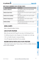
Loss of GPS Position, GPS Receiver Status
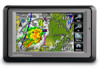 |
View all Garmin aera 560 manuals
Add to My Manuals
Save this manual to your list of manuals |
Page 45 highlights
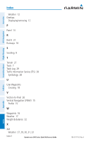
A G Aircraft Profile 31 Airspace Messages 34 Approaches 25 Aural Alerts 37 B Battery Charging 3 Installation 2 BKSP 4 Bug Indicator 14 C CDI Scale 14 Charging, the battery 3 Course, setting 14 D Data Entry 10 Alphanumeric Data 10 Predetermined Data Option 10 Data Fields 13, 35 Direct-to 4, 19 Cancelling 20 GPS Navigation 13 GPS Receiver Status 3 H Hazard Display 37 'Home' Screen 5 HSI/Panel 14 K Keypad 4 L Loss of GPS Position 37 M Map Overlays 12 Panning 11 Range 12 Map Feature Information 11 Message Advisories 33 Modes Changing 3 E E6B Calculator 30 F Flight Log 29 Flight Plan Activation 24 Adding Waypoints 23 Creation 21 Data Fields 21 Deletion 24 Storage 23 N Navigation Controls 4 Nearest 5, 17 Numeric Data Options 35 Numeric Flight Data 13 O Option Menu 9 Overlay Satellite Imagery 12 Terrain 12 Topography 12 190-01117-03 Rev. A Garmin aera 500 Series Quick Reference Guide Index Index-1 Index Appendix Utilities Flight Planning Hazard Avoidance GPS Navigation Overview
-
 1
1 -
2
-
3
-
4
-
5
-
6
-
7
-
8
-
9
-
10
-
11
-
12
-
13
-
14
-
15
-
16
-
17
-
18
-
19
-
20
-
21
-
22
-
23
-
24
-
25
-
26
-
27
-
28
-
29
-
30
-
31
-
32
-
33
-
34
-
35
-
36
-
37
-
38
-
39
-
 40
40 -
 41
41 -
 42
42 -
 43
43 -
 44
44 -
 45
45 -
 46
46 -
 47
47 -
 48
48
 |
 |
