Garmin eTrex Summit Owner's Manual (Software Version 3.00 and above) &nbs - Page 58
Units
 |
View all Garmin eTrex Summit manuals
Add to My Manuals
Save this manual to your list of manuals |
Page 58 highlights
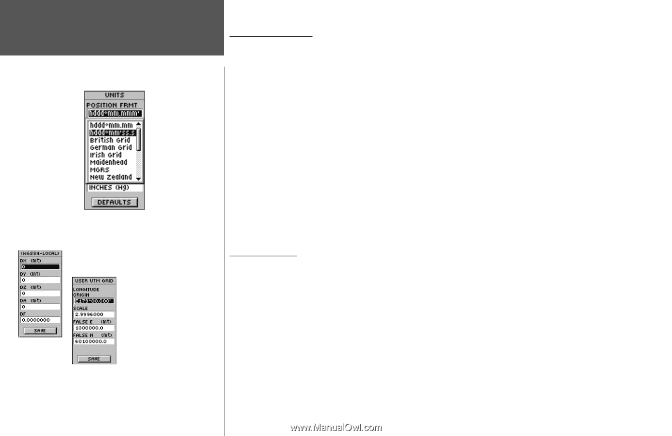
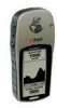
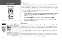
Setup Page Units Page Eighteen position formats are available in the eTrex Summit. Position Format The default position format (and the one most commonly used) for the eTrex Summit is latitude and longitude in degrees and minutes (hdddº mm.mmm). You may also choose from 17 other position formats. There is also a "User" position format which allows you to approximate custom-designed grids. For more information on grids and datums we recommend you visit the National Imagery and Mapping Agency at http://www.nima.mil. To change the Position Format: 1. Press the PAGE button and switch to the MENU Page. Press the UP or DOWN button and highlight 'SETUP'. Press ENTER. Press the UP/DOWN buttons to select 'UNITS'. Press ENTER. The UNITS Page appears. 2. Press the UP or DOWN button to select the 'POSITION FRMT' field. Press ENTER. 3. Press the UP or DOWN button to select the desired format. Press ENTER. Press PAGE to get back to the page of your choice. User Datum 44 User Grid Data entry pages for the User Grid Format and the User Datum Setup allow you to configure the eTrex Summit for compatibility with custom designed grids. We recommend surfing the net for links to Garmin user-grid and user datum information. There are also excellent navigation and GPS articles available on-line which will enhance your overall knowledge of GPS. Map Datums A map datum is a reference model of the earth's shape. Every map uses a map datum. The map datum is usually listed in the title block of the map. If you are comparing GPS coordinates to a paper map or other reference, the map datum in the eTrex Summit should match the horizontal map datum used to generate the chart or other reference. The default datum in the eTrex Summit is WGS 84 (World Geodetic Survey, 1984). You should only change the datum if you are using maps or charts that specify a different datum than WGS 84. If no datum is specified, you can select each datum applicable to your region until you find the datum that provides the best positioning at a known point. You may also choose the "User" datum for use with custom-designed grids.
-
 1
1 -
2
-
3
-
4
-
5
-
6
-
7
-
8
-
9
-
10
-
11
-
12
-
13
-
14
-
15
-
16
-
17
-
18
-
19
-
20
-
21
-
22
-
23
-
24
-
25
-
26
-
27
-
28
-
29
-
30
-
31
-
32
-
33
-
34
-
35
-
36
-
37
-
38
-
39
-
40
-
41
-
42
-
43
-
44
-
45
-
46
-
47
-
48
-
49
-
50
-
51
-
52
-
 53
53 -
 54
54 -
 55
55 -
 56
56 -
 57
57 -
 58
58 -
 59
59 -
 60
60 -
 61
61 -
 62
62 -
 63
63 -
64
-
65
-
66
-
67
-
68
-
69
-
70
-
71
-
72
-
73
-
74
-
75
-
76
-
77
-
78
-
79
-
80
 |
 |