Macrom M-NV iGo Primo - Page 66
Traffic information in route planning
 |
View all Macrom M-NV manuals
Add to My Manuals
Save this manual to your list of manuals |
Page 66 highlights
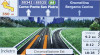
iGO primo is connected to the GPS receiver, but the signal is too weak and the receiver cannot determine the GPS position. GPS navigation is not possible. Only a few satellites are received. Position information is available, but elevation (altitude) cannot be calculated. GPS navigation is possible, but the position error may be significant. Altitude information is available, the position is a 3D position. GPS navigation is possible. 5.1.7 Traffic information in route planning The recommended route is not always the same between two points. Real-time traffic information can help you avoid current traffic events like temporary road closures or a traffic jam caused by an accident. The function is subject to data availability. You can display the live traffic information on the map if you browse the map and select this option from the More menu. A 2D map is displayed with road segments coloured by the severity of traffic events. Tap the event type icon at the road segment and then tap the button to get information about the traffic event. 5.1.7.1 Real-time traffic information (TMC) TMC (Traffic Message Channel) can provide you with the real-time status of the traffic. Route calculation can avoid road blocks or unexpected traffic jams caused by an accident. Note! This feature is available only if your hardware supports TMC. TMC is a specific application of the FM Radio Data System (RDS) used for broadcasting realtime traffic and weather information. Using traffic information is enabled by default in iGO primo. Note! TMC is not a global service. It may not be available in your country or region. Ask your local dealer for coverage details. You need a TMC receiver attached to your device to receive Traffic events. If public Traffic data is broadcast at your location, iGO primo automatically takes into account the traffic events received. You do not need to set anything in the program. The receiver will automatically search the FM radio stations for TMC data, and the decoded information will immediately be used in route planning. When iGO primo receives traffic information that may affect your route, the program will warn you that it is recalculating the route, and navigation 66
-
 1
1 -
2
-
3
-
4
-
5
-
6
-
7
-
8
-
9
-
10
-
11
-
12
-
13
-
14
-
15
-
16
-
17
-
18
-
19
-
20
-
21
-
22
-
23
-
24
-
25
-
26
-
27
-
28
-
29
-
30
-
31
-
32
-
33
-
34
-
35
-
36
-
37
-
38
-
39
-
40
-
41
-
42
-
43
-
44
-
45
-
46
-
47
-
48
-
49
-
50
-
51
-
52
-
53
-
54
-
55
-
56
-
57
-
58
-
59
-
60
-
 61
61 -
 62
62 -
 63
63 -
 64
64 -
 65
65 -
 66
66 -
 67
67 -
 68
68 -
 69
69 -
 70
70 -
 71
71 -
72
-
73
-
74
-
75
-
76
-
77
-
78
-
79
-
80
-
81
 |
 |
