Magellan RoadMate 6000T Manual - English - Page 76
Set GPS Position, 1.11 Simulator Mode
 |
UPC - 763357115055
View all Magellan RoadMate 6000T manuals
Add to My Manuals
Save this manual to your list of manuals |
Page 76 highlights
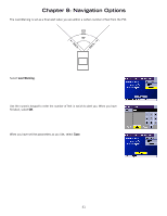
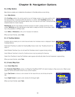
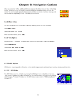
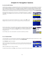
Chapter 8: Navigation Options 8.1.10.2 Set GPS Position Set GPS Position enables you to manually set the location of the Current Position icon. If you have travelled a long distance with the Magellan RoadMate 6000T off, it may take some time for the Magellan RoadMate 6000T to reacquire a satellite signal. By manually setting the position of the Magellan RoadMate 6000T, you are telling the Magellan RoadMate 6000T where you are and will speed up the satellite signal acquisition. Make sure you first select the country you are in by pressing the Globe button on the Destination screen (see "Country Selection (Globe Button)" on page 27). Select Set GPS Position. Enter the first few characters of the city name (see "Inputting Text Characters" on page 14). Select OK. Use the Navigation key to scroll the list up or down (if necessary) and select the desired city. Enter the street name (see "Help with Address Entry" on page 16). Select OK. Use the Navigation key to scroll the list up or down (if necessary) and select the desired street. Enter the street address. The acceptable range of numbers is displayed at the top of the screen. If you do not know the exact address, just select Done and the Magellan RoadMate 6000T will use the lowest number in the range. Select Done to continue. You will be returned to the Configuration menu. Go to the Map screen. Your current position is now set to the address you entered. 8.1.11 Simulator Mode In Simulator Mode, you can demonstrate the capabilities of the Magellan RoadMate 6000T without actually driving. In order for the simulation to work, you must set a route first. Select Simulator Mode. Select Simulate to begin the simulation. Set the speed variance of the simulation: x1 will "drive" at normal speed using known speed limits; x1.5 will "drive" at one and a half times normal speed; x2 will "drive" at two times normal speed. Return to the Map screen to view the simulation. To disable Simulator Mode, select Stop, or when the power is turned off the Simulator will stop. 66
-
 1
1 -
2
-
3
-
4
-
5
-
6
-
7
-
8
-
9
-
10
-
11
-
12
-
13
-
14
-
15
-
16
-
17
-
18
-
19
-
20
-
21
-
22
-
23
-
24
-
25
-
26
-
27
-
28
-
29
-
30
-
31
-
32
-
33
-
34
-
35
-
36
-
37
-
38
-
39
-
40
-
41
-
42
-
43
-
44
-
45
-
46
-
47
-
48
-
49
-
50
-
51
-
52
-
53
-
54
-
55
-
56
-
57
-
58
-
59
-
60
-
61
-
62
-
63
-
64
-
65
-
66
-
67
-
68
-
69
-
70
-
 71
71 -
 72
72 -
 73
73 -
 74
74 -
 75
75 -
 76
76 -
 77
77 -
 78
78 -
 79
79 -
 80
80 -
 81
81 -
82
-
83
-
84
-
85
-
86
-
87
-
88
-
89
-
90
-
91
-
92
-
93
-
94
-
95
-
96
-
97
-
98
-
99
-
100
-
101
-
102
-
103
-
104
-
105
-
106
-
107
-
108
-
109
-
110
-
111
-
112
-
113
-
114
-
115
-
116
-
117
-
118
-
119
-
120
-
121
 |
 |
