Garmin GPSMAP 496 Owner's Manual (for North America) - Page 191
GPSMAP 496 Owner's Manual, LORAN TD setup - 78 gps
 |
View all Garmin GPSMAP 496 manuals
Add to My Manuals
Save this manual to your list of manuals |
Page 191 highlights
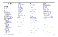
intersection 170 J Jeppesen database 27, 170 updates 10 K keypad 7 L land at closest point 19 language 116 legs, track 90 limited warranty 177 line out 1 lithium-ion 2 lithium-ion battery 1 local time 119 location 6, 65 location format 120, 167 locked route 27 log filter 113 longitude 175 LORAN TD setup 165-166 lost satellite reception 5 M magnetic variation 120 main menu Display Tab 114 GPS tab 4 GPSMAP 496 Owner's Manual Sound Tab 115 managing routes 74 managing tracks 87 managing waypoints 78 Man OverBoard 92 map information 36, 60 MapSource 10, 160 map data 36 map datum 167 map orientation 30 Map Page automotive mode 69 aviation mode 29-36 declutter 33 marine mode 93 setup 34 marine timer 95 maritime mobile service identity. See MMSI marking a waypoint 26, 63, 64, 65, 81 underwater 139 mark my location 26 maximum speed 47 MayDay 169 measuring distance 33 messages 113, 177-180 military time 119 Mils 119 MMSI 96, 168, 169 MOB 92 modes 55, 116 moon information 109 N navigate route 75 to point 92 track 90 navigating distress call 100 position report 100 navigating in automotive mode 56-57 navigating in marine mode 92 navigation alarms 106 NDB 18, 170 near current route 59, 60 destination 59, 60 next 59, 60 other 59, 60 NEAREST/FIND key 18 nearest type 45, 73 new altitude 6 location 6, 12 waypoint 65, 81 next turn 106, 118 NMEA 122, 124, 161 north up 6, 30 no beacon signal 164 O OBS 41 obstacle alert 28 odometer 73 off-route recalculation 118 off course 107 off road 117 on-screen button 8 options menu 9 overzoom 30 P page layout 35 page sequence 91 panel page aviation mode 40-43 panning the map 29, 31 pan mode 29, 31 PC interface cable 160 persistent alarm 106 plan flight 44, 77 plan route 44, 77 points of interest 58 Points tab 83 pop-up alerts 28 position 163 position data page aviation mode 45 Index 183
-
 1
1 -
2
-
3
-
4
-
5
-
6
-
7
-
8
-
9
-
10
-
11
-
12
-
13
-
14
-
15
-
16
-
17
-
18
-
19
-
20
-
21
-
22
-
23
-
24
-
25
-
26
-
27
-
28
-
29
-
30
-
31
-
32
-
33
-
34
-
35
-
36
-
37
-
38
-
39
-
40
-
41
-
42
-
43
-
44
-
45
-
46
-
47
-
48
-
49
-
50
-
51
-
52
-
53
-
54
-
55
-
56
-
57
-
58
-
59
-
60
-
61
-
62
-
63
-
64
-
65
-
66
-
67
-
68
-
69
-
70
-
71
-
72
-
73
-
74
-
75
-
76
-
77
-
78
-
79
-
80
-
81
-
82
-
83
-
84
-
85
-
86
-
87
-
88
-
89
-
90
-
91
-
92
-
93
-
94
-
95
-
96
-
97
-
98
-
99
-
100
-
101
-
102
-
103
-
104
-
105
-
106
-
107
-
108
-
109
-
110
-
111
-
112
-
113
-
114
-
115
-
116
-
117
-
118
-
119
-
120
-
121
-
122
-
123
-
124
-
125
-
126
-
127
-
128
-
129
-
130
-
131
-
132
-
133
-
134
-
135
-
136
-
137
-
138
-
139
-
140
-
141
-
142
-
143
-
144
-
145
-
146
-
147
-
148
-
149
-
150
-
151
-
152
-
153
-
154
-
155
-
156
-
157
-
158
-
159
-
160
-
161
-
162
-
163
-
164
-
165
-
166
-
167
-
168
-
169
-
170
-
171
-
172
-
173
-
174
-
175
-
176
-
177
-
178
-
179
-
180
-
181
-
182
-
183
-
184
-
185
-
 186
186 -
 187
187 -
 188
188 -
 189
189 -
 190
190 -
 191
191 -
 192
192 -
 193
193 -
 194
194
 |
 |
