Garmin aera 550 Pilot's Guide - Page 117
Additional Features, 5.1 SafeTaxi - pacific
 |
View all Garmin aera 550 manuals
Add to My Manuals
Save this manual to your list of manuals |
Page 117 highlights
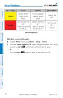
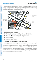
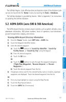
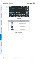
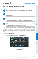
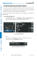
Overview Additional Features Section 5 Additional Features NOTE: With the availability of SafeTaxi in electronic form, it is still advisable to carry another source of charts on board the aircraft. The following additional features are included with the aera depending on the unit. Additional Features aera 500 510 550 560 GPS Navigation Americas Atlantic Pacific Americas Americas Atlantic Pacific Americas Flight Planning Hazard Avoidance Additional Features AOPA Airport Directory SafeTaxi® XM® + + + + + + aera 500/510/550/560 Additional Features 5.1 SafeTaxi SafeTaxi is an enhanced feature that gives greater map detail when viewing airports at close range. When viewing at ranges close enough to show the airport detail, the map reveals taxiways with identifying letters/numbers, runway incursion "Hot Spot", and airport landmarks including ramps, buildings, control towers, and other prominent features. Resolution is greater at lower map ranges. The SafeTaxi feature can be seen on the Navigation Map or from the Waypoint Information Runway Tab. Designated Hot Spots are recognized at airports with many intersecting taxiways and runways, and/or complex ramp areas. Airport Hot Spots are outlined to caution pilots of areas on an airport surface where positional awareness confusion or runway incursions happen most often. Hot Spots are defined by a red shaded area. Appendices Index 190-01117-02 Rev. A Garmin aera 500 Series Pilot's Guide 105
-
 1
1 -
2
-
3
-
4
-
5
-
6
-
7
-
8
-
9
-
10
-
11
-
12
-
13
-
14
-
15
-
16
-
17
-
18
-
19
-
20
-
21
-
22
-
23
-
24
-
25
-
26
-
27
-
28
-
29
-
30
-
31
-
32
-
33
-
34
-
35
-
36
-
37
-
38
-
39
-
40
-
41
-
42
-
43
-
44
-
45
-
46
-
47
-
48
-
49
-
50
-
51
-
52
-
53
-
54
-
55
-
56
-
57
-
58
-
59
-
60
-
61
-
62
-
63
-
64
-
65
-
66
-
67
-
68
-
69
-
70
-
71
-
72
-
73
-
74
-
75
-
76
-
77
-
78
-
79
-
80
-
81
-
82
-
83
-
84
-
85
-
86
-
87
-
88
-
89
-
90
-
91
-
92
-
93
-
94
-
95
-
96
-
97
-
98
-
99
-
100
-
101
-
102
-
103
-
104
-
105
-
106
-
107
-
108
-
109
-
110
-
111
-
 112
112 -
 113
113 -
 114
114 -
 115
115 -
 116
116 -
 117
117 -
 118
118 -
 119
119 -
 120
120 -
 121
121 -
 122
122 -
123
-
124
-
125
-
126
-
127
-
128
-
129
-
130
-
131
-
132
-
133
-
134
-
135
-
136
-
137
-
138
-
139
-
140
-
141
-
142
-
143
-
144
-
145
-
146
-
147
-
148
-
149
-
150
-
151
-
152
-
153
-
154
-
155
-
156
-
157
-
158
-
159
-
160
-
161
-
162
-
163
-
164
-
165
-
166
-
167
-
168
-
169
-
170
-
171
-
172
-
173
-
174
-
175
-
176
-
177
-
178
-
179
-
180
-
181
-
182
-
183
-
184
-
185
-
186
-
187
-
188
-
189
-
190
-
191
-
192
-
193
-
194
-
195
-
196
-
197
-
198
-
199
-
200
-
201
-
202
 |
 |
