Lowrance HDS-9 Gen2 Touch Operation Manual - Page 23
Chart menu
 |
View all Lowrance HDS-9 Gen2 Touch manuals
Add to My Manuals
Save this manual to your list of manuals |
Page 23 highlights
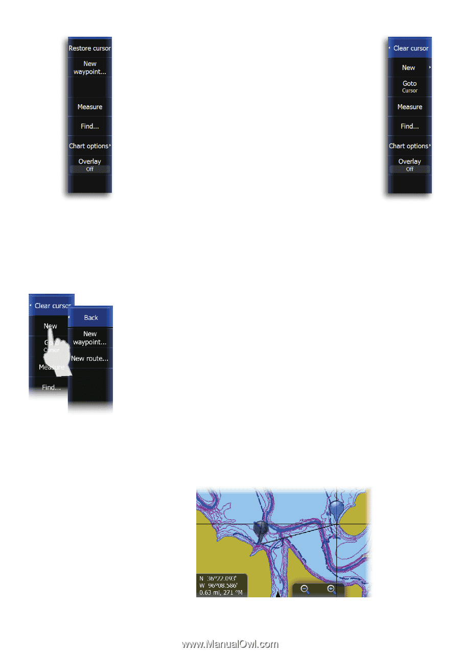
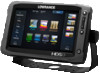
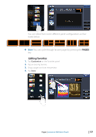
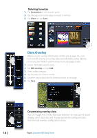
Chart menu When the cursor is active, some features on the chart menu will be replaced with cursor mode features. Tap Clear cursor to return to the normal chart menu. No cursor Saving waypoints When the cursor is not active, you can save a waypoint at the vessel position by tapping New waypoint on the chart menu. Using the touchscreen to save a waypoint at the cursor: 1. Tap the desired location on the screen 2. Tap New on the chart menu Active cursor 3. Tap New waypoint and tap Save ¼¼ Note: You can also save a waypoint by pressing the dedicated waypoint key twice. With the cursor active, the waypoint will be saved at the cursor position. When the cursor is inactive, the waypoint will be saved at the vessel position. Creating routes You can quickly create routes on the chart page. 1. Tap the screen to activate the cursor 2. Tap New on the menu 3. Tap New route 4. Tap the screen to position the first routepoint. Tap the screen to place more routepoints 5. Save the route by tapping Save on the menu Measuring distance The cursor can be used to measure the distance between your vessel and a selected position, or between two points on the chart. Chart | Lowrance HDS Gen2 Touch | 21
-
 1
1 -
2
-
3
-
4
-
5
-
6
-
7
-
8
-
9
-
10
-
11
-
12
-
13
-
14
-
15
-
16
-
17
-
 18
18 -
 19
19 -
 20
20 -
 21
21 -
 22
22 -
 23
23 -
 24
24 -
 25
25 -
 26
26 -
 27
27 -
 28
28 -
29
-
30
-
31
-
32
-
33
-
34
-
35
-
36
-
37
-
38
-
39
-
40
-
41
-
42
-
43
-
44
-
45
-
46
-
47
-
48
-
49
-
50
-
51
-
52
-
53
-
54
-
55
-
56
-
57
-
58
-
59
-
60
-
61
-
62
-
63
-
64
-
65
-
66
-
67
-
68
-
69
-
70
-
71
-
72
-
73
-
74
-
75
-
76
-
77
-
78
-
79
-
80
-
81
-
82
-
83
-
84
-
85
-
86
-
87
-
88
-
89
-
90
-
91
-
92
-
93
-
94
-
95
-
96
-
97
-
98
-
99
-
100
-
101
-
102
-
103
-
104
-
105
-
106
-
107
-
108
-
109
-
110
-
111
-
112
-
113
-
114
-
115
-
116
-
117
-
118
-
119
-
120
-
121
-
122
-
123
-
124
-
125
-
126
-
127
-
128
-
129
-
130
-
131
-
132
-
133
-
134
-
135
-
136
-
137
 |
 |