Lowrance HDS-9 Gen2 Touch Operation Manual - Page 30
Navionics chart options
 |
View all Lowrance HDS-9 Gen2 Touch manuals
Add to My Manuals
Save this manual to your list of manuals |
Page 30 highlights
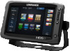
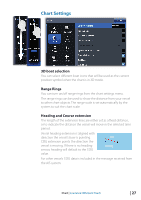
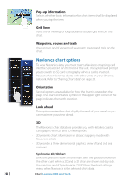
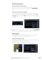
Pop-up information Selects whether basic information for chart items shall be displayed when you tap the item. Grid lines Turns on/off viewing of longitude and latitude grid lines on the chart. Waypoints, routes and trails You can turn on/off viewing of waypoints, routes and trails on the chart. Navionics chart options To view Navionics data, you must insert a Navionics mapping card into the SD card slot on the front of the unit. The system will prompt you to switch to SD card cartography when a card is inserted. You can share Navionics charts with other units on your Ethernet network. Refer to "Sharing Chart data" on page 26. Orientation Several options are available for how the chart is rotated on the page. The chart orientation symbol in the upper right corner of the page indicates the north direction. Look ahead This option centers the chart slightly forward of your vessel so you can maximize your view ahead. 3D The Navionics chart database provides you with detailed coastal cartography, with 2D and 3D view options. • 2D presents chart information in a basic mapping mode with Navionics details • 3D provides a three dimensional graphical view of land and sea contours Synchronize 2D/3D chart Links the position shown on one chart with the position shown on the other chart when a 2D and a 3D chart are shown side by side. You can turn on/off Synchronize 2D/3D from the chart settings menu when Navionics is the selected chart data. 28 | Chart | Lowrance HDS Gen2 Touch
-
 1
1 -
2
-
3
-
4
-
5
-
6
-
7
-
8
-
9
-
10
-
11
-
12
-
13
-
14
-
15
-
16
-
17
-
18
-
19
-
20
-
21
-
22
-
23
-
24
-
 25
25 -
 26
26 -
 27
27 -
 28
28 -
 29
29 -
 30
30 -
 31
31 -
 32
32 -
 33
33 -
 34
34 -
 35
35 -
36
-
37
-
38
-
39
-
40
-
41
-
42
-
43
-
44
-
45
-
46
-
47
-
48
-
49
-
50
-
51
-
52
-
53
-
54
-
55
-
56
-
57
-
58
-
59
-
60
-
61
-
62
-
63
-
64
-
65
-
66
-
67
-
68
-
69
-
70
-
71
-
72
-
73
-
74
-
75
-
76
-
77
-
78
-
79
-
80
-
81
-
82
-
83
-
84
-
85
-
86
-
87
-
88
-
89
-
90
-
91
-
92
-
93
-
94
-
95
-
96
-
97
-
98
-
99
-
100
-
101
-
102
-
103
-
104
-
105
-
106
-
107
-
108
-
109
-
110
-
111
-
112
-
113
-
114
-
115
-
116
-
117
-
118
-
119
-
120
-
121
-
122
-
123
-
124
-
125
-
126
-
127
-
128
-
129
-
130
-
131
-
132
-
133
-
134
-
135
-
136
-
137
 |
 |