Pioneer CNDV-40R Operation Manual - Page 98
About operation of the DVD, player, Positioning Technology, Positioning by GPS, Positioning by dead
 |
View all Pioneer CNDV-40R manuals
Add to My Manuals
Save this manual to your list of manuals |
Page 98 highlights
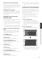
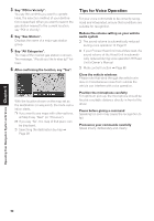
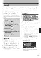
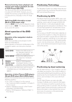
Reverse frame by frame playback and reverse slow motion playback (in case of XDV-P9 and XDV-P90) You cannot do this with the Remote Control included with AVIC-9DVD. However, you can operate this function using the Remote Control included with the DVD player or the AV Head Unit. Switching DVD information screen (Built-in DVD player only) Press the DISP button while the Operation mode switch is set to "DVD". The display switches over as you press the button. About operation of the DVD player Operation of the navigation's built-in DVD drive DVD videos and CDs can be played on AVIC9DVD and AVIC-90DVD. About operation of the built-in DVD player of the navigation system, see instruction manuals below: AVIC-9DVD AVIC-90DVD CD-R10, CD-R11 (sold separately) Refer to the DVD section in the "Operation Manual" provided with AVIC-9DVD. Refer to the DVD section in the respective "Hardware Manual". Refer to "DVD Operation (Keyfinder2)"section in the respective "Owner's Manual". ❒ You cannot play DVD-Video with the built-in DVD-ROM drive of AVIC-80DVD and AVIC88DVD. Operation of other Pioneer DVD players (Single DVD player/Multi-DVD player) Refer to the following manual and section for the detailed operation: • See "DVD" in Chapter 5 on this manual. • See "Used when DVD is operated" in Chapter 5 in this manual. • Refer to "Operation manual" of the Pioneer DVD player (S-DVD/M-DVD). • Refer to "DVD Operation Reference Table" in this manual. Positioning Technology The Navigation System accurately measures your current location by combining the positioning by GPS and by Dead Reckoning. Positioning by GPS The Global Positioning System (GPS) uses a network of satellites orbiting the Ground. Each of the satellites, which orbit at a height of 68,900,000 feet (21,000 km), continually broadcasts radio signals giving time and position information. This ensures that signals from at least three can be picked up from any open area on the ground's surface. The accuracy of the GPS information depends on how good the reception is. When the signals are strong and reception is good, GPS can determine latitude, longitude, and altitude for accurate positioning in three dimensions. But if signal quality is poor, only two dimensions, latitude and longitude, can be obtained and positioning errors are somewhat greater. Positioning by dead reckoning The 3D Hybrid Sensor in the navigation unit also calculates your position. The current location is measured by detecting driving distance with the speed pulse, the turning direction with the Gyrosensor, and inclination of the road with the G sensor. The 3D Hybrid Sensor can even calculate changes of altitude, and corrects for discrepancies in the distance travelled caused by driving along winding roads or up slopes. Also, the Navigation System learns the driving conditions and stores information in the memory; thus, as you drive more, the precision of the positioning becomes more accurate. Appendix 96
-
 1
1 -
2
-
3
-
4
-
5
-
6
-
7
-
8
-
9
-
10
-
11
-
12
-
13
-
14
-
15
-
16
-
17
-
18
-
19
-
20
-
21
-
22
-
23
-
24
-
25
-
26
-
27
-
28
-
29
-
30
-
31
-
32
-
33
-
34
-
35
-
36
-
37
-
38
-
39
-
40
-
41
-
42
-
43
-
44
-
45
-
46
-
47
-
48
-
49
-
50
-
51
-
52
-
53
-
54
-
55
-
56
-
57
-
58
-
59
-
60
-
61
-
62
-
63
-
64
-
65
-
66
-
67
-
68
-
69
-
70
-
71
-
72
-
73
-
74
-
75
-
76
-
77
-
78
-
79
-
80
-
81
-
82
-
83
-
84
-
85
-
86
-
87
-
88
-
89
-
90
-
91
-
92
-
 93
93 -
 94
94 -
 95
95 -
 96
96 -
 97
97 -
 98
98 -
 99
99 -
 100
100 -
 101
101 -
 102
102 -
 103
103 -
104
-
105
-
106
-
107
-
108
-
109
-
110
-
111
-
112
-
113
-
114
-
115
-
116
-
117
-
118
-
119
-
120
 |
 |
