2012 Dodge Charger User Guide - Page 50
2012 Dodge Charger Manual

Page 50 highlights
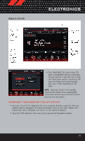
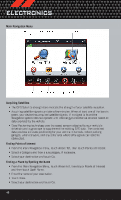
ELECTRONICS Main Navigation Menu Acquiring Satellites • The GPS Satellite strength bars indicate the strength of your satellite reception. • Acquiring satellite signals can take a few minutes. When at least one of the bars is green, your device has acquired satellite signals. If no signal is found the Navigation system still can operate with internal gyro direction & location based on data provided by the vehicle. • Dead Reckoning technology uses the speed sensors attached to your vehicle's drivetrain and a gyroscope to supplement the existing GPS data. The combined data provides accurate positioning for your vehicle in tunnels, indoor parking garages, urban canyons, and any other area where GPS signals can become obstructed. Finding Points of Interest • From the main Navigation menu, touch Where To?, then touch Points of Interest. • Select a Category and then a subcategory, if necessary. • Select your destination and touch Go. Finding a Place by Spelling the Name • From the Main Navigation Menu, touch Where to?, then touch Points of Interest and then touch Spell Name. • Enter the name of your destination. • Touch Done. • Select your destination and touch Go. 48
-
 1
1 -
2
-
3
-
4
-
5
-
6
-
7
-
8
-
9
-
10
-
11
-
12
-
13
-
14
-
15
-
16
-
17
-
18
-
19
-
20
-
21
-
22
-
23
-
24
-
25
-
26
-
27
-
28
-
29
-
30
-
31
-
32
-
33
-
34
-
35
-
36
-
37
-
38
-
39
-
40
-
41
-
42
-
43
-
44
-
 45
45 -
 46
46 -
 47
47 -
 48
48 -
 49
49 -
 50
50 -
 51
51 -
 52
52 -
 53
53 -
 54
54 -
 55
55 -
56
-
57
-
58
-
59
-
60
-
61
-
62
-
63
-
64
-
65
-
66
-
67
-
68
-
69
-
70
-
71
-
72
-
73
-
74
-
75
-
76
-
77
-
78
-
79
-
80
-
81
-
82
-
83
-
84
-
85
-
86
-
87
-
88
-
89
-
90
-
91
-
92
-
93
-
94
-
95
-
96
-
97
-
98
-
99
-
100
-
101
-
102
-
103
-
104
-
105
-
106
-
107
-
108
-
109
-
110
-
111
-
112
-
113
-
114
-
115
-
116
-
117
-
118
-
119
-
120
-
121
-
122
-
123
-
124
-
125
-
126
-
127
-
128
-
129
-
130
 |
 |
