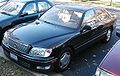
1998 Lexus LS 400 Navigation Manual - Page 10
1998 Lexus LS 400 Manual
Page 10 highlights
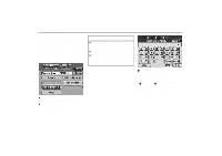
Symbols and Switches on Map Screen 1008U Current Vehicle Position Mark 1013U GPS Mark (Global Positioning System) 1019U Display of Point of Interest Indicates the current position. 12-1 North-Up Symbol and Scale of Map On reception of signals from the GPS, this mark is displayed. 1015U 1016U Symbols such as restaurants and hotels, etc. can be displayed on the screen. For details, see page 47. 1031U Deletion of Point of Interest Indicates the map with North up. Touching this symbol directly on the screen changes to the map with heading-up. The figure indicates the map scale. For details, see page 51. 12-2 Heading-Up Symbol and Scale of Map Magnification or reduction of the map scale. For details, see page 50. 1017U Canceling the Route Guidance Symbols such as restaurants and hotels, etc. displayed on the screen can be deleted. For details, see page 47. 1020U Setting of Detour (on the map screen) The screen displays the "CANCEL GUIDANCE" mode. For details, see page 41. 1018U One - Touch Registration of Marked Point 1021U Registers the current vehicle position as a marked point. For details, see page 58. Voice Guidance A detour can be set in the route guidance mode to avoid a traffic jam caused by road repairs or an accident. For details, see page 46. Indicates the map with the vehicle travel direction up. The red triangle shows North. Touching this symbol directly on the screen changes to the map with North-up. If you cannot hear voice guidance, you can hear it once again. 6
-
 1
1 -
2
-
3
-
4
-
 5
5 -
 6
6 -
 7
7 -
 8
8 -
 9
9 -
 10
10 -
 11
11 -
 12
12 -
 13
13 -
 14
14 -
 15
15 -
16
-
17
-
18
-
19
-
20
-
21
-
22
-
23
-
24
-
25
-
26
-
27
-
28
-
29
-
30
-
31
-
32
-
33
-
34
-
35
-
36
-
37
-
38
-
39
-
40
-
41
-
42
-
43
-
44
-
45
-
46
-
47
-
48
-
49
-
50
-
51
-
52
-
53
-
54
-
55
-
56
-
57
-
58
-
59
-
60
-
61
-
62
-
63
-
64
-
65
-
66
-
67
-
68
-
69
-
70
-
71
-
72
-
73
-
74
-
75
-
76
-
77
-
78
-
79
-
80
-
81
-
82
-
83
-
84
-
85
-
86
-
87
-
88
-
89
-
90
-
91
-
92
-
93
-
94
-
95
-
96
-
97
-
98
-
99
-
100
-
101
-
102
-
103
-
104
-
105
-
106
-
107
-
108
-
109
-
110
 |
 |
