Garmin Drive Owners Manual - Page 9
Search Tools, Parking, Viewing Recently Found Locations, Viewing Current Location Information, - 50
 |
View all Garmin Drive manuals
Add to My Manuals
Save this manual to your list of manuals |
Page 9 highlights
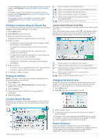
2 Select an option: • To search for the venue, enter the name or address of the venue, select , and go to step 3. • To search for the POI, enter the name of the POI, select , and go to step 5. 3 Select the venue. A list of categories appears below the venue, such as restaurants, car rentals, or terminals. 4 Select a category. 5 Select the POI, and select Go!. The device creates a route to the parking area or venue entrance closest to the POI. When you arrive at the destination, a checkered flag indicates the recommended parking area. A labeled point indicates the location of the POI within the venue. Exploring a Venue NOTE: This feature may not be available in all areas or for all product models. You can view a list of all points of interest located within each venue. 1 Select a venue. 2 Select > Explore this Venue. Search Tools Search tools allow you to search for specific types of locations by responding to on-screen prompts. Finding an Intersection You can search for an intersection or junction between two streets, highways, or other roads. 1 Select Where To? > Categories > Intersections. 2 Follow the on-screen instructions to enter street information. 3 Select the intersection. Finding a Location Using Coordinates You can find a location using latitude and longitude coordinates. 1 Select Where To? > Coordinates. 2 If necessary, select , and change the coordinate format or datum. 3 Enter the latitude and longitude coordinates. 4 Select View on Map. Parking Your Garmin DriveSmart device includes detailed parking data, which can help you find nearby parking based on the likelihood of available parking spots, type of parking area, price, or accepted payment methods. NOTE: Detailed parking data is not available in all areas or for all parking locations. Finding Parking Near Your Current Location 1 Select Where To? > Categories > Parking. 2 Select Filter Parking, and select one or more categories to filter parking by availability, type, price, or payment methods (optional). NOTE: Detailed parking data is not available in all areas or for all parking locations. 3 Select a parking location. 4 Select Go!. Finding Parking Near a Specified Location 1 Search for a location. 2 From the location search results, select a location. 3 Select . A list of parking areas near the selected location appears. 4 Select Filter Parking, and select one or more categories to filter parking by availability, type, price, or payment methods (optional). NOTE: Detailed parking data is not available in all areas or for all parking locations. 5 Select a parking location. 6 Select Go!. Understanding Parking Colors and Symbols Parking locations that include detailed parking data are colorcoded to show the likelihood of finding parking. Symbols indicate the type of parking available (street or lot), relative pricing information, and payment type. You can view the legend for these colors and symbols on the device. From the parking search results, select . Viewing Recently Found Locations Your device stores a history of the last 50 locations you have found. Select Where To? > Recent. Clearing the List of Recently Found Locations Select Where To? > Recent > > Clear > Yes. Viewing Current Location Information You can use the Where Am I? page to view information about your current location. This feature is helpful if you need to tell emergency personnel your location. From the map, select the vehicle. Finding Emergency Services and Fuel You can use the Where Am I? page to find the nearest hospitals, police stations, and fuel stations. 1 From the map, select the vehicle. 2 Select Hospitals, Police Stations, Fuel, or Roadside Assist.. NOTE: Some service categories are not available in all areas. A list of locations for the selected service appears, with the nearest locations at the top. 3 Select a location. 4 Select an option: • To navigate to the location, select Go!. • To view the phone number and other location details, select . Getting Directions to Your Current Location If you need to tell another person how to get to your current location, your device can give you a list of directions. 1 From the map, select the vehicle. 2 Select > Directions to Me. 3 Select a starting location. 4 Select Select. Adding a Shortcut You can add shortcuts to the Where To? menu. A shortcut can point to a location, a category, or a search tool. The Where To? menu can contain up to 36 shortcut icons. 1 Select Where To? > Add Shortcut. 2 Select an item. Finding and Saving Locations 5
-
 1
1 -
2
-
3
-
 4
4 -
 5
5 -
 6
6 -
 7
7 -
 8
8 -
 9
9 -
 10
10 -
 11
11 -
 12
12 -
 13
13 -
 14
14 -
15
-
16
-
17
-
18
-
19
-
20
-
21
-
22
-
23
-
24
-
25
-
26
-
27
-
28
 |
 |
