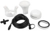
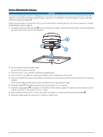
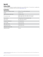
Garmin GPS 24xd Receiver and Antenna Installation Instructions - Page 9
Performing Basic Calibration, If you are performing the first basic calibration after a factory reset
 |
View all Garmin GPS 24xd Receiver and Antenna manuals
Add to My Manuals
Save this manual to your list of manuals |
Page 9 highlights
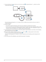
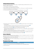
Performing Basic Calibration If you connect the antenna to a NMEA 2000 network without a compatible Garmin chartplotter or with a third-party device, you must perform basic calibration instead of menu-based calibration. Before you can perform basic calibration, you must be able to view heading data from the NMEA 2000 network on a connected device. To perform basic calibration, you must remove from the network all sources of heading data other than the antenna. When performing basic calibration, you first calibrate the compass and then align the heading in one continuous procedure. NOTE: The boat must be able to reach a cruising speed of at least 6.4 km/h (4 mph) to perform the heading alignment. 1 Drive the boat to a location with calm, open water. 2 Set the display to view heading data from the connected antenna. NOTE: You must not use GPS Course Over Ground (COG) to perform basic calibration. 3 Disconnect the antenna from the NMEA 2000 network or turn off the power to the NMEA 2000 network. 4 Wait while the boat becomes level and stationary. 5 Turn on power to the antenna, and wait until the heading data appears on the display . NOTE: If you are performing the first basic calibration after a factory reset, the heading is blank. 6 Within three minutes, complete two full, slow, tight circles , taking care to keep the boat as steady and level as possible. The boat should not list during calibration. When the antenna is prepared to calibrate the compass, the heading data disappears from the display . You may receive an error message that the heading was lost. You can ignore this message. 9
-
 1
1 -
2
-
3
-
 4
4 -
 5
5 -
 6
6 -
 7
7 -
 8
8 -
 9
9 -
 10
10 -
 11
11 -
 12
12 -
 13
13 -
 14
14 -
15
-
16
 |
 |
