Garmin GPSMAP 420s Owner's Manual - Page 23
Using Fish Eye 3D, Fish Eye 3D Settings - transducer
 |
UPC - 753759065799
View all Garmin GPSMAP 420s manuals
Add to My Manuals
Save this manual to your list of manuals |
Page 23 highlights
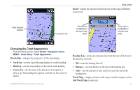
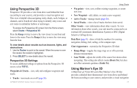
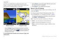
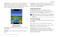
Hazard Colors-Turns hazard colors on or off. The Off setting shows the land as seen from the water. The On setting indicates shallow water and land with a color scale. Blue indicates deep water, yellow is shallow water, and red is very shallow water. Using Charts Lane Width-adjusts the width of the course line drawn when navigating. This setting also affects routes (Route To), but does not affect automatic guidance (Guide To). Using Fish Eye 3D Using the depth contour lines of the BlueChart g2 Vision cartography, Fish Eye 3D provides an underwater view of the sea floor or lake bottom. Use the Range keys to adjust the view. Note: You must have an "s" series unit (such as a GPSMAP 420s) and a transducer wired through a marine network to receive sonar information. Mariner's Eye 3D (Water Hazard Colors) Range Rings-toggles the range rings on or off to provide distance measurement. Safe Depth-adjusts the depth at which red indicates dangerous depths. Fish Eye 3D Settings To access additional settings or options for the Fish Eye 3D screen, press MENU. View-selects a fish eye view of fore, aft, port, or starboard. Sonar Cone (only available if sonar is present)-turns a cone that shows the area covered by your transducer on or off. Fish Symbols (only available if sonar is present)-displays suspended targets (such as fish). Targets are indicated by red, green, and yellow spheres. Red indicates the largest targets and green indicates the smallest targets. GPSMAP 400/500 Series Owner's Manual 17
-
 1
1 -
2
-
3
-
4
-
5
-
6
-
7
-
8
-
9
-
10
-
11
-
12
-
13
-
14
-
15
-
16
-
17
-
 18
18 -
 19
19 -
 20
20 -
 21
21 -
 22
22 -
 23
23 -
 24
24 -
 25
25 -
 26
26 -
 27
27 -
 28
28 -
29
-
30
-
31
-
32
-
33
-
34
-
35
-
36
-
37
-
38
-
39
-
40
-
41
-
42
-
43
-
44
-
45
-
46
-
47
-
48
-
49
-
50
-
51
-
52
-
53
-
54
-
55
-
56
-
57
-
58
-
59
-
60
-
61
-
62
-
63
-
64
-
65
-
66
-
67
-
68
-
69
-
70
-
71
-
72
 |
 |
