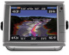
Garmin GPSMAP 7212 Supplement
Garmin GPSMAP 7212 Manual
 |
View all Garmin GPSMAP 7212 manuals
Add to My Manuals
Save this manual to your list of manuals |
Garmin GPSMAP 7212 manual content summary:
- Garmin GPSMAP 7212 | Supplement - Page 1
XM WX Satellite Weather® and XM® Satellite Radio supplement - Garmin GPSMAP 7212 | Supplement - Page 2
without the express prior written consent of Garmin. Garmin hereby grants permission to download a single copy of this manual onto a hard drive or other electronic of this and other Garmin products. Garmin®, the Gamin logo, GPSMAP®, BlueChart®, and g2 Vision® are trademarks of Garmin Ltd. or its - Garmin GPSMAP 7212 | Supplement - Page 3
. If you do not have a receiver and a subscription to XM WX Satellite Weather, the weather features described in this manual work only when a chartplotter is in simulator mode. Simulator mode does not supply live weather data. Contact Garmin Contact Garmin Product Support if you have any questions - Garmin GPSMAP 7212 | Supplement - Page 4
...i Contact Garmin...i XM WX Satellite Weather and XM Satellite Radio 1 XM WX Satellite Weather...1 Viewing XM WX Satellite Weather Subscription Information 11 XM Satellite Radio...11 Appendix...14 Weather Data Warranty...14 Software License Agreement...15 XM Satellite Radio Service Agreement 15 - Garmin GPSMAP 7212 | Supplement - Page 5
A Garmin XM satellite weather receiver and antenna receives XM WX Satellite Weather data and shows it on various Garmin devices, including the Navigation chart on a chartplotter. The weather data for each feature comes from reputable weather data centers such as the National Weather Service and - Garmin GPSMAP 7212 | Supplement - Page 6
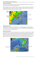
indicates the projected path of the hurricane. Darkened dots on the red line indicate the projected locations through which the hurricane will pass, as received from the National Hurricane Center. The center provides four forecasts at 12-hour intervals (12 hours, 24 hours, 36 hours, and 48 hours - Garmin GPSMAP 7212 | Supplement - Page 7
the warning area. The cyan lines on the chart indicate the boundaries of marine weather warning zones. Marine warning area Marine warning zone boundaries County Warnings When the National Weather Service issues a weather warning for a county, the county is highlighted with the color corresponding - Garmin GPSMAP 7212 | Supplement - Page 8
the Home screen, select Weather > Forecast. 2. Pan the map to an offshore location. The Marine Forecast or Offshore Forecast options appear when forecast information is available. 3. Select Marine Forecast or Offshore Forecast. Weather Fronts and Pressure Centers Weather fronts appear as lines that - Garmin GPSMAP 7212 | Supplement - Page 9
XM WX Satellite Weather and XM Satellite Radio Viewing Sea Conditions The sea conditions screen shows information about surface conditions, including winds, wave height, wave period, and wave direction. From the Home screen, select Weather > Sea Conditions. Surface Winds Surface winds appear on - Garmin GPSMAP 7212 | Supplement - Page 10
XM WX Satellite Weather and XM Satellite Radio Viewing Fishing Information The fishing screen shows present water temperature, present surface pressure conditions, and fishing forecasts. From the Home screen, select Weather > Fishing. Surface Pressure Surface-pressure information appears using - Garmin GPSMAP 7212 | Supplement - Page 11
XM WX Satellite Weather and XM Satellite Radio Visibility Information Visibility is the forecast maximum horizontal distance that can be seen at the surface, as shown in the legend on the left of the screen. Variations in the visibility shading show the forecast change in surface visibility. - Garmin GPSMAP 7212 | Supplement - Page 12
. to view present weather conditions from a local weather service. • Select Forecast to view a local weather forecast. and barometric pressure information. • Select Marine Bulletin to view wind and wave information or the Fishing chart on a chartplotter. Weather Overlay settings configured for use - Garmin GPSMAP 7212 | Supplement - Page 13
XM WX Satellite Weather and XM Satellite Radio Turning On the Weather Overlay on a Chart Note: The Fishing chart is available with a preprogrammed BlueChart® g2 Vision® data card. 1. From the Home screen, select Charts. 2. Select Navigation Chart or Fishing Chart. 3. Select Menu > Chart Setup > - Garmin GPSMAP 7212 | Supplement - Page 14
to sound when certain weather conditions occur. 1. From the Home screen, select Configure > Alarms > Weather. 2. Complete one or more actions: • Select Marine > On. • Select Tornado > On. • Select Severe Storm > On. • Select Flood > On. • Select Flash Flood > On. 10 XM WX Satellite Weather® and - Garmin GPSMAP 7212 | Supplement - Page 15
service was updated. From the Home screen, select Weather > Weather Subscription. XM Satellite Radio When a Garmin XM audio receiver and antenna is connected to the Garmin Marine an XM channel number manually. Enter a channel number. Select Done. Customizing the Channel Guide XM Radio channels are - Garmin GPSMAP 7212 | Supplement - Page 16
Audio. 2. Complete an action: • Select Channel Guide to select a specific XM channel within the or on. • Select Volume to adjust the volume level manually. Select and hold Up or Down. Select Done. XM bar is available on all charts. On a chartplotter, a data bar configured to appear on one chart - Garmin GPSMAP 7212 | Supplement - Page 17
the XM Radio data bar along the bottom of the Combinations screen on a chartplotter. For more information, see the "Combinations" chapter of the GPSMAP 6000/7000 Series Owner's Manual. 1. From the Home screen, select Combinations. 2. Select a combination. 3. Select Menu > Change Combination > XM - Garmin GPSMAP 7212 | Supplement - Page 18
the Radio Service. In no event will XM and Garmin, their data suppliers, service providers, marketing SERVICE THAT YOU RECEIVED DURING THE SIX (6) MONTH PERIOD IMMEDIATELY PRIOR TO THE SPECIFIC EVENT THAT GAVE RISE TO THE APPLICABLE DAMAGE OR LOSS. THIS ALLOCATION OF RISK IS REFLECTED IN OUR PRICES - Garmin GPSMAP 7212 | Supplement - Page 19
Software License Agreement BY USING THE CHARTPLOTTER, YOU AGREE TO BE BOUND BY . PLEASE READ THIS AGREEMENT CAREFULLY. Garmin Ltd. and its subsidiaries ("Garmin") grant you a limited license to and available at xmradio.com. XM Radio U.S. Satellite Services available only to those at least 18 years of - Garmin GPSMAP 7212 | Supplement - Page 20
channel guide 11 cloud cover 1 county warnings 3 F fish location 6 forecasts 3 city 4 future 3 marine 4 offshore 4 past 3 present 3 weather 3 H hurricane 2 L lightning 2 M marine warnings 3 N National Weather Service 1 NEXRAD precipitation 1 P presets 12 pressure centers 4 R radio receiver i S storm - Garmin GPSMAP 7212 | Supplement - Page 21
- Garmin GPSMAP 7212 | Supplement - Page 22
- Garmin GPSMAP 7212 | Supplement - Page 23
- Garmin GPSMAP 7212 | Supplement - Page 24
updates (excluding map data) throughout the life of your Garmin products, visit the Garmin Web site at www.garmin.com. © 2010 Garmin Ltd. or its subsidiaries Garmin International, Inc. 1200 East 151st Street, Olathe, Kansas 66062, USA Garmin (Europe) Ltd. Liberty House, Hounsdown Business Park
-
 1
1 -
 2
2 -
 3
3 -
 4
4 -
 5
5 -
 6
6 -
 7
7 -
8
-
9
-
10
-
11
-
12
-
13
-
14
-
15
-
16
-
17
-
18
-
19
-
20
-
21
-
22
-
23
-
24
 |
 |

XM WX Satellite Weather
®
and XM
®
Satellite Radio
supplement