Garmin GPSMAP 7212 Supplement - Page 14
Weather Alarms, Charts, Navigation Chart, Chart Setup, Weather, Visibility, Fishing Chart, Sea Temp
 |
View all Garmin GPSMAP 7212 manuals
Add to My Manuals
Save this manual to your list of manuals |
Page 14 highlights
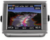
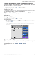
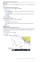
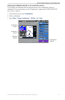
XM WX Satellite Weather and XM Satellite Radio Showing Visibility Data on the Navigation Chart Before you can show visibility data on the Navigation chart, you must turn on the Weather Overlay (page 9). Visibility is the forecast maximum horizontal distance that can be seen at the surface. From the Home screen, select Charts > Navigation Chart > Menu > Chart Setup > Weather > Visibility > On. Showing Sea Temperature Data on the Fishing Chart Before you can show sea temperature data on the Fishing chart, you must turn on the Weather Overlay (page 9). Note: The Fishing chart is available with a preprogrammed BlueChart g2 Vision data card. From the Home screen, select Charts > Fishing Chart > Menu > Chart Setup > Weather > Sea Temp > On. Showing Fish Forecasting Data on the Fishing Chart Before you can show fish forecasting data on the Fishing chart, you must turn on the Weather Overlay (page 9). You can show areas that contain optimal weather conditions for specific species of fish. Note: The Fishing chart is available with a preprogrammed BlueChart g2 Vision data card. 1. From the Home screen, select Charts > Fishing Chart > Menu > Chart Setup > Weather > Fish Species > On. 2. Select a species of fish. 3. Select Mode > On. Shaded areas indicate optimal fishing areas. 4. Repeat steps 2 and 3 to show areas with optimal weather conditions for additional species of fish. Weather Alarms Setting Weather Alarms You can set an alarm to sound when certain weather conditions occur. 1. From the Home screen, select Configure > Alarms > Weather. 2. Complete one or more actions: • Select Marine > On. • Select Tornado > On. • Select Severe Storm > On. • Select Flood > On. • Select Flash Flood > On. 10 XM WX Satellite Weather® and XM® Satellite Radio Supplement
-
 1
1 -
2
-
3
-
4
-
5
-
6
-
7
-
8
-
 9
9 -
 10
10 -
 11
11 -
 12
12 -
 13
13 -
 14
14 -
 15
15 -
 16
16 -
 17
17 -
 18
18 -
 19
19 -
20
-
21
-
22
-
23
-
24
 |
 |
