Garmin GTN 750 STC GTN 6XX/7XX AFMS - Page 5
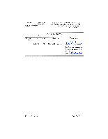
GENERAL, Garmin GTN Navigators, Table 1 - GTN Functions - marker beacon
 |
View all Garmin GTN 750 manuals
Add to My Manuals
Save this manual to your list of manuals |
Page 5 highlights
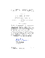
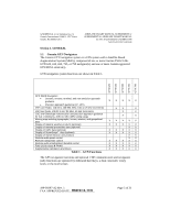
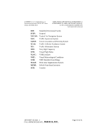
GTN 625 GTN 635 GTN 650 GTN 725 GTN 750 GARMIN Ltd. or its Subsidiaries, c/o Garmin International 1200 E. 151st Street Olathe, KS 66062 USA AIRPLANE FLIGHT MANUAL SUPPLEMENT or SUPPLEMENTAL AIRPLANE FLIGHT MANUAL for STC SA02019SE-D GARMIN GTN NAVIGATION SYSTEM Section 1. GENERAL 1.1 Garmin GTN Navigators The Garmin GTN navigation system is a GPS system with a Satellite Based Augmentation System (SBAS), comprised of one or more Garmin TSO-C146c GTN 625, 635, 650, 725, or 750 navigator(s) and one or more Garmin approved GPS/SBAS antenna(s). GTN navigation system functions are shown in Table 1. GPS SBAS Navigation: • Oceanic, enroute, terminal, and non-precision approach guidance X X XXX • Precision approach guidance (LP, LPV) VHF Com Radio, 118.00 to 136.990, MHz, 8.33 or 25 kHz increments X X X VHF Nav Radio, 108.00 to 117.95 MHz, 50 kHz increments X X LOC and Glideslope non-precision and precision approach guidance for Cat 1 minimums, 328.6 to 335.4 MHz tuning range Moving map including topographic, terrain, aviation, and geopolitical data Display of datalink weather products (optional) X X X X XXX X X XXX Display of terminal procedures data (optional) X X Display of traffic data (optional) Display of StormScope® data (optional) Display of marker beacon annunciators X X XXX X X XXX X X Remote audio panel control X X Remote transponder control X X XXX Remote audio entertainment datalink control TSO-C151b Class B TAWS Supplemental calculators and timers X X XXX X X XXX X X XXX Table 1 - GTN Functions The GPS navigation functions and optional VHF communication and navigation radio functions are operated by dedicated hard keys, a dual concentric rotary knob, or the touchscreen. 190-01007-A2 Rev. 1 FAA APPROVED DATE: _M__A_R_C_H__1_8__,_2_0_1_1__ Page 5 of 31
-
 1
1 -
 2
2 -
 3
3 -
 4
4 -
 5
5 -
 6
6 -
 7
7 -
 8
8 -
 9
9 -
 10
10 -
 11
11 -
12
-
13
-
14
-
15
-
16
-
17
-
18
-
19
-
20
-
21
-
22
-
23
-
24
-
25
-
26
-
27
-
28
-
29
-
30
-
31
 |
 |
