Garmin aera 795 Pilot's Guide - Page 57
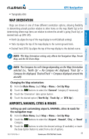
Map Orientation, Airports, Navaids, Cities & Roads, Main Menu, Set Up Map, General, North Up, Track Up
 |
View all Garmin aera 795 manuals
Add to My Manuals
Save this manual to your list of manuals |
Page 57 highlights
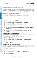
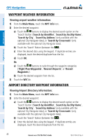
Overview GPS Navigation GPS Navigation • Topography data MAP ORIENTATION Maps are shown in one of three different orientation options, allowing flexibility in determining aircraft position relative to other items on the map (North Up) or for determining where map items are relative to where the aircraft is going (Track Up), or desired track up (DTK UP)). • North Up aligns the top of the map display to north (default setting). • Track Up aligns the top of the map display to the current ground track. • Desired Track (DTK) Up aligns the top of the map display to the desired course. NOTE: The Map Orientation setting only affects the Navigation Map, Terrain Map, and the 3D Vision Map. Flight Planning Hazard Avoidance Additional Features Appendices NOTE: The Compass Arc will change depending on the Map Orientation selected (i.e., 'North Up' = No Compass Arc displayed, 'Track Up' = Compass Arc displayed, 'Desired Track' = Compass displayed around the aircraft). Changing the Map orientation: 1) From the Main Menu, touch Map > Menu > Set Up Map 2) Touch the buttons to select the 'General' Category (if necessary). 3) Touch the 'Orientation' data option button. 4) Touch the desired option ('North Up', 'Track Up', or 'DTK Up'). AIRPORTS, NAVAIDS, CITIES & ROADS Setting up and customizing airports, NAVAIDs, cities & roads for the navigation map: 1) From the Main Menu, touch Map > Menu > Set Up Map 2) Touch the Category. buttons to select the 'Airport', 'Navaid', 'City', or 'Road' 3) Touch the buttons to select the desired settings (if available), or touch the Data Option Button to select from a list of options. 190-01194-00 Rev. A Garmin aera 795/796 Pilot's Guide 43 Index
-
 1
1 -
2
-
3
-
4
-
5
-
6
-
7
-
8
-
9
-
10
-
11
-
12
-
13
-
14
-
15
-
16
-
17
-
18
-
19
-
20
-
21
-
22
-
23
-
24
-
25
-
26
-
27
-
28
-
29
-
30
-
31
-
32
-
33
-
34
-
35
-
36
-
37
-
38
-
39
-
40
-
41
-
42
-
43
-
44
-
45
-
46
-
47
-
48
-
49
-
50
-
51
-
 52
52 -
 53
53 -
 54
54 -
 55
55 -
 56
56 -
 57
57 -
 58
58 -
 59
59 -
 60
60 -
 61
61 -
 62
62 -
63
-
64
-
65
-
66
-
67
-
68
-
69
-
70
-
71
-
72
-
73
-
74
-
75
-
76
-
77
-
78
-
79
-
80
-
81
-
82
-
83
-
84
-
85
-
86
-
87
-
88
-
89
-
90
-
91
-
92
-
93
-
94
-
95
-
96
-
97
-
98
-
99
-
100
-
101
-
102
-
103
-
104
-
105
-
106
-
107
-
108
-
109
-
110
-
111
-
112
-
113
-
114
-
115
-
116
-
117
-
118
-
119
-
120
-
121
-
122
-
123
-
124
-
125
-
126
-
127
-
128
-
129
-
130
-
131
-
132
-
133
-
134
-
135
-
136
-
137
-
138
-
139
-
140
-
141
-
142
-
143
-
144
-
145
-
146
-
147
-
148
-
149
-
150
-
151
-
152
-
153
-
154
-
155
-
156
-
157
-
158
-
159
-
160
-
161
-
162
-
163
-
164
-
165
-
166
-
167
-
168
-
169
-
170
-
171
-
172
-
173
-
174
-
175
-
176
-
177
-
178
-
179
-
180
-
181
-
182
-
183
-
184
-
185
-
186
-
187
-
188
-
189
-
190
-
191
-
192
-
193
-
194
-
195
-
196
-
197
-
198
-
199
-
200
-
201
-
202
-
203
-
204
-
205
-
206
-
207
-
208
-
209
-
210
 |
 |
