Garmin aera 795 Pilot's Guide - Page 61
Waypoint Frequencies
 |
View all Garmin aera 795 manuals
Add to My Manuals
Save this manual to your list of manuals |
Page 61 highlights
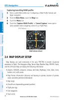
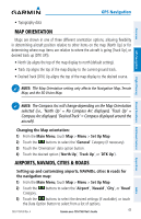
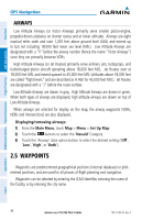
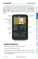
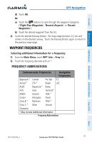
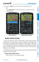
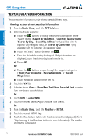
Overview GPS Navigation Flight Planning Hazard Avoidance Additional Features GPS Navigation d) Touch OK. Or: a) Touch the buttons to cycle through the waypoint categories ('Flight Plan Waypoints', 'Nearest Airports', or 'Recent Waypoints'). b) Touch the desired waypoint from the list. 4) Touch the desired Runway Button. The map range becomes 0.2 nm and centers on the desired runway. Touch the Runway Button again to return to the previous map range. WAYPOINT FREQUENCIES Selecting additional information for a frequency: 1) From the Main Menu, touch WPT Info > Freq Tab. 2) Touch the frequency denoted with an *. FREQUENCY ABBREVIATIONS Communication Frequencies Navigation Frequencies Approach * Control Pre-Taxi ILS Arrival * CTA * Radar LOC ASOS Departure * Ramp ATIS Gate Terminal* AWOS Ground TMA * Center Helicopter Tower Class B * Multicom TRSA * Class C * Other Unicom Clearance * May include Additional Information Frequency Abbreviations Appendices Index 190-01194-00 Rev. A Garmin aera 795/796 Pilot's Guide 47
-
 1
1 -
2
-
3
-
4
-
5
-
6
-
7
-
8
-
9
-
10
-
11
-
12
-
13
-
14
-
15
-
16
-
17
-
18
-
19
-
20
-
21
-
22
-
23
-
24
-
25
-
26
-
27
-
28
-
29
-
30
-
31
-
32
-
33
-
34
-
35
-
36
-
37
-
38
-
39
-
40
-
41
-
42
-
43
-
44
-
45
-
46
-
47
-
48
-
49
-
50
-
51
-
52
-
53
-
54
-
55
-
 56
56 -
 57
57 -
 58
58 -
 59
59 -
 60
60 -
 61
61 -
 62
62 -
 63
63 -
 64
64 -
 65
65 -
 66
66 -
67
-
68
-
69
-
70
-
71
-
72
-
73
-
74
-
75
-
76
-
77
-
78
-
79
-
80
-
81
-
82
-
83
-
84
-
85
-
86
-
87
-
88
-
89
-
90
-
91
-
92
-
93
-
94
-
95
-
96
-
97
-
98
-
99
-
100
-
101
-
102
-
103
-
104
-
105
-
106
-
107
-
108
-
109
-
110
-
111
-
112
-
113
-
114
-
115
-
116
-
117
-
118
-
119
-
120
-
121
-
122
-
123
-
124
-
125
-
126
-
127
-
128
-
129
-
130
-
131
-
132
-
133
-
134
-
135
-
136
-
137
-
138
-
139
-
140
-
141
-
142
-
143
-
144
-
145
-
146
-
147
-
148
-
149
-
150
-
151
-
152
-
153
-
154
-
155
-
156
-
157
-
158
-
159
-
160
-
161
-
162
-
163
-
164
-
165
-
166
-
167
-
168
-
169
-
170
-
171
-
172
-
173
-
174
-
175
-
176
-
177
-
178
-
179
-
180
-
181
-
182
-
183
-
184
-
185
-
186
-
187
-
188
-
189
-
190
-
191
-
192
-
193
-
194
-
195
-
196
-
197
-
198
-
199
-
200
-
201
-
202
-
203
-
204
-
205
-
206
-
207
-
208
-
209
-
210
 |
 |
