Garmin eTrex 20 Quick Start Manual - Page 5
Calibrating the Compass, Selecting a Profile, waypoints - geocaching
 |
View all Garmin eTrex 20 manuals
Add to My Manuals
Save this manual to your list of manuals |
Page 5 highlights
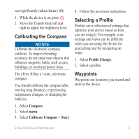
can significantly reduce battery life. 1. While the device is on, press . 2. Move the Thumb Stick left and right to adjust the brightness level. Calibrating the Compass Notice Calibrate the electronic compass outdoors. To improve heading accuracy, do not stand near objects that influence magnetic fields, such as cars, buildings, or overhead power lines. The eTrex 30 has a 3-axis, electronic compass. You should calibrate the compass after moving long distances, experiencing temperature changes, or changing the batteries. 1. Select Compass. 2. Select menu. 3. Select Calibrate Compass > Start. 4. Follow the on-screen instructions. Selecting a Profile Profiles are a collection of settings that optimize your device based on how you are using it. For example, your settings and views can be different when you are using the device for geocaching and for navigating on water. 1. Select Profile Change. 2. Select a profile. Waypoints Waypoints are locations you record and store in the device. eTrex 20/30 Quick Start Manual 5
-
 1
1 -
 2
2 -
 3
3 -
 4
4 -
 5
5 -
 6
6 -
 7
7 -
 8
8 -
 9
9 -
 10
10 -
 11
11 -
12
 |
 |