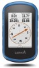
Garmin eTrex Touch 25 Owners Manual - Page 12
Changing the Units of Measure - how to use
 |
View all Garmin eTrex Touch 25 manuals
Add to My Manuals
Save this manual to your list of manuals |
Page 12 highlights
North Reference: Sets the north reference used on the compass. Go To Line (Pointer): Allows you to use the bearing pointer that points in the direction of your destination, or use the course pointer that shows your relationship to the course line leading to the destination. Compass: Automatically switches from an electronic compass to a GPS compass when you are traveling at a higher rate of speed for a period of time. Calibrate Compass: Allows you to calibrate the compass if you experience irregular compass behavior, for example, after moving long distances or after extreme temperature changes. See Calibrating the Compass, page 4. Altimeter Settings Select Setup > Altimeter. Auto Calibration: Automatically calibrates the altimeter each time the device is turned on. The device continues to automatically calibrate the altimeter as long as the device has GPS signals acquired. Barometer Mode: Variable Elevation allows the barometer to measure changes in elevation while you are moving. Fixed Elevation assumes the device is stationary at a fixed elevation, so the barometric pressure should only change due to weather. Pressure Trending: Sets how the device records pressure data. Save Always can be useful when you are watching for pressure fronts. Plot Type: Records elevation changes over a period of time or distance, records barometric pressure over a period of time, or records ambient pressure changes over a period of time. Calibrate Altimeter: Allows you to calibrate the barometric altimeter if you know the correct elevation or the correct barometric pressure. See Calibrating the Barometric Altimeter, page 5. Position Format Settings NOTE: You should not change the position format or the map datum coordinate system unless you are using a map or chart that specifies a different position format. Select Setup > Position Format. Position Format: Sets the position format in which a location reading appears. Map Datum: Sets the coordinate system on which the map is structured. Map Spheroid: Shows the coordinate system the device is using. The default coordinate system is WGS 84. Changing the Units of Measure You can customize units of measure for distance and speed, elevation, depth, temperature, pressure, and vertical speed. 1 Select Setup > Units. 2 Select a measurement type. 3 Select a unit of measure. Time Settings Select Setup > Time. Time Format: Sets the device to show time in a 12-hour or 24- hour format. Time Zone: Sets the time zone for the device. Automatic sets the time zone automatically based on your GPS position. Appearance: Allows you to set the display style for geocache data, and display the geocache list by names or codes. chirp Searching: Allows the device to search for a geocache containing a chirp accessory (Enabling chirp Searching, page 5). Program chirp: Programs the chirp accessory. See the chirp Owner's Manual at www.garmin.com. Filter Setup: Allows you to create and save custom filters for geocaches (Creating and Saving a Geocache Filter, page 5). Found Geocaches: Allows you to edit the number of geocaches found. This number automatically increases when you log a find (Logging the Attempt, page 6). ANT+ Sensor Settings For more information about optional fitness accessories, see Optional Fitness Accessories, page 7. Fitness Settings Select Setup > Fitness. Auto Lap: Sets the device to automatically mark the lap at a specific distance. User: Sets the user profile information (Setting Your Fitness User Profile, page 10). HR Zones: Sets the five heart rate zones for fitness activities. Activity Type: Sets the fitness activity to running, cycling, or other. This allows your running activity to appear as a running activity when you transfer it to Garmin Connect. Setting Your Fitness User Profile The device uses information that you enter about yourself to calculate accurate data. You can modify the following user profile information: gender, age, weight, height, and lifetime athlete (About Lifetime Athletes, page 10). 1 Select Setup > Fitness > User. 2 Modify the settings. About Lifetime Athletes A lifetime athlete is an individual who has trained intensely for many years (with the exception of minor injuries) and has a resting heart rate of 60 beats per minute (bpm) or less. Marking Laps by Distance You can use Auto Lap® to automatically mark the lap at a specific distance. This feature is helpful for comparing your performance over different parts of an activity. 1 Select Setup > Fitness > Auto Lap. 2 Enter a value, and select . Marine Settings Select Setup > Marine. Marine Chart Mode: Sets the type of chart the device uses when displaying marine data. Nautical displays various map features in different colors so the marine POIs are more readable and so the map reflects the drawing scheme of paper charts. Fishing (requires marine maps) displays a detailed view of bottom contours and depth soundings and simplifies map presentation for optimal use while fishing. Appearance: Sets the appearance of marine navigation aids on the map. Marine Alarm Setup: Sets alarms for when you exceed a specified drift distance while anchored, when you are off course by a specified distance, and when you enter water of a specific depth. Geocaching Settings Select Setup > Geocaching. Setting Up Marine Alarms 1 Select Setup > Marine > Marine Alarm Setup. 10 Customizing the Device
-
 1
1 -
2
-
3
-
4
-
5
-
6
-
 7
7 -
 8
8 -
 9
9 -
 10
10 -
 11
11 -
 12
12 -
 13
13 -
 14
14 -
 15
15 -
 16
16 -
 17
17 -
18
 |
 |