Lowrance HDS-12 Gen3 Operators Manual US - Page 49
: Waypoints, Routes, and Trails, and Trails dialogs, Tools panel, Settings
 |
View all Lowrance HDS-12 Gen3 manuals
Add to My Manuals
Save this manual to your list of manuals |
Page 49 highlights
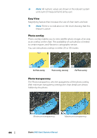
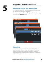
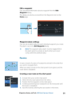
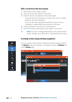
5 Waypoints, Routes, and Trails Waypoints, Routes, and Trails dialogs The Waypoints, Routes, and Trails dialogs give access to advanced edit functions and settings for these items. The dialogs are accessed from the Tools panel on the Home page or from the chart Settings dialog. Waypoints A waypoint is a user generated mark positioned on a chart, on a radar image or on the Sonar image. Each waypoint has an exact position with latitude and longitude coordinates. A waypoint positioned from the Sonar image has a depth value, in addition to position information. Waypoints, Routes, and Trails | HDS Gen3 Operator Manual 49
-
 1
1 -
2
-
3
-
4
-
5
-
6
-
7
-
8
-
9
-
10
-
11
-
12
-
13
-
14
-
15
-
16
-
17
-
18
-
19
-
20
-
21
-
22
-
23
-
24
-
25
-
26
-
27
-
28
-
29
-
30
-
31
-
32
-
33
-
34
-
35
-
36
-
37
-
38
-
39
-
40
-
41
-
42
-
43
-
 44
44 -
 45
45 -
 46
46 -
 47
47 -
 48
48 -
 49
49 -
 50
50 -
 51
51 -
 52
52 -
 53
53 -
 54
54 -
55
-
56
-
57
-
58
-
59
-
60
-
61
-
62
-
63
-
64
-
65
-
66
-
67
-
68
-
69
-
70
-
71
-
72
-
73
-
74
-
75
-
76
-
77
-
78
-
79
-
80
-
81
-
82
-
83
-
84
-
85
-
86
-
87
-
88
-
89
-
90
-
91
-
92
-
93
-
94
-
95
-
96
-
97
-
98
-
99
-
100
-
101
-
102
-
103
-
104
-
105
-
106
-
107
-
108
-
109
-
110
-
111
-
112
-
113
-
114
-
115
-
116
-
117
-
118
-
119
-
120
-
121
-
122
-
123
-
124
-
125
-
126
-
127
-
128
-
129
-
130
-
131
-
132
-
133
-
134
-
135
-
136
-
137
-
138
-
139
-
140
-
141
-
142
-
143
-
144
-
145
-
146
-
147
-
148
-
149
-
150
-
151
-
152
-
153
-
154
-
155
-
156
-
157
-
158
-
159
-
160
-
161
-
162
-
163
-
164
-
165
-
166
 |
 |

Waypoints, Routes, and Trails
Waypoints, Routes, and Trails dialogs
The Waypoints, Routes, and Trails dialogs give access to advanced
edit functions and settings for these items.
The dialogs are accessed from the
Tools panel
on the
Home
page
or from the chart
Settings
dialog.
Waypoints
A waypoint is a user generated mark positioned on a chart, on a
radar image or on the Sonar image. Each waypoint has an exact
position with latitude and longitude coordinates. A waypoint
positioned from the Sonar image has a depth value, in addition to
position information.
5
Waypoints, Routes, and Trails
| HDS Gen3 Operator Manual
49