Lowrance HDS-9 LIVE HDS Live Operator Manual - Page 36
Color trails, 3D charts, Controlling the view angle
 |
View all Lowrance HDS-9 LIVE manuals
Add to My Manuals
Save this manual to your list of manuals |
Page 36 highlights
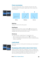
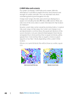
Activate the cursor on the panel to search from the cursor position. If the cursor is not active, the system searches for items from the vessel's position. Ú Note: You must have a SiriusXM Marine subscription to search for fueling stations. Ú Note: You must have an AIS receiver connected to search for vessels. Color trails A trail can be colored based on source data and high/low limits settings. Refer to "Color trails based on data" on page 58. 3D charts The 3D option provides a three dimensional graphical view of land and sea contours. Ú Note: All chart types work in 3D mode, but without 3D cartography for the appropriate area the chart appears flat. When the 3D chart option is selected, the rotate (A) and the pan (B) icons appear on the chart panel. Controlling the view angle You can control the view angle by selecting the rotate icon, and then panning the chart panel. • To change the direction you are viewing, pan horizontally • To change the tilt angle of the view, pan vertically Ú Note: When centered on the vessel position, only the tilt angle can be adjusted. The view direction is controlled by the chart orientation setting. Refer to "Chart orientation" on page 33. 36 Charts | HDS Live Operator Manual
-
 1
1 -
2
-
3
-
4
-
5
-
6
-
7
-
8
-
9
-
10
-
11
-
12
-
13
-
14
-
15
-
16
-
17
-
18
-
19
-
20
-
21
-
22
-
23
-
24
-
25
-
26
-
27
-
28
-
29
-
30
-
 31
31 -
 32
32 -
 33
33 -
 34
34 -
 35
35 -
 36
36 -
 37
37 -
 38
38 -
 39
39 -
 40
40 -
 41
41 -
42
-
43
-
44
-
45
-
46
-
47
-
48
-
49
-
50
-
51
-
52
-
53
-
54
-
55
-
56
-
57
-
58
-
59
-
60
-
61
-
62
-
63
-
64
-
65
-
66
-
67
-
68
-
69
-
70
-
71
-
72
-
73
-
74
-
75
-
76
-
77
-
78
-
79
-
80
-
81
-
82
-
83
-
84
-
85
-
86
-
87
-
88
-
89
-
90
-
91
-
92
-
93
-
94
-
95
-
96
-
97
-
98
-
99
-
100
-
101
-
102
-
103
-
104
-
105
-
106
-
107
-
108
-
109
-
110
-
111
-
112
-
113
-
114
-
115
-
116
-
117
-
118
-
119
-
120
-
121
-
122
-
123
-
124
-
125
-
126
-
127
-
128
-
129
-
130
-
131
-
132
-
133
-
134
-
135
-
136
-
137
-
138
-
139
-
140
-
141
-
142
-
143
-
144
-
145
-
146
-
147
-
148
-
149
-
150
-
151
-
152
-
153
-
154
-
155
-
156
-
157
-
158
-
159
-
160
-
161
-
162
-
163
-
164
-
165
-
166
-
167
-
168
-
169
-
170
-
171
-
172
-
173
-
174
-
175
-
176
-
177
-
178
-
179
-
180
-
181
-
182
-
183
-
184
-
185
-
186
-
187
-
188
-
189
-
190
-
191
-
192
-
193
-
194
-
195
-
196
-
197
-
198
 |
 |
