Magellan eXplorist 210 Manual - English - Page 84
Selecting the Background or Detail Map, Setting the Map Units - topo maps
 |
UPC - 763357112702
View all Magellan eXplorist 210 manuals
Add to My Manuals
Save this manual to your list of manuals |
Page 84 highlights
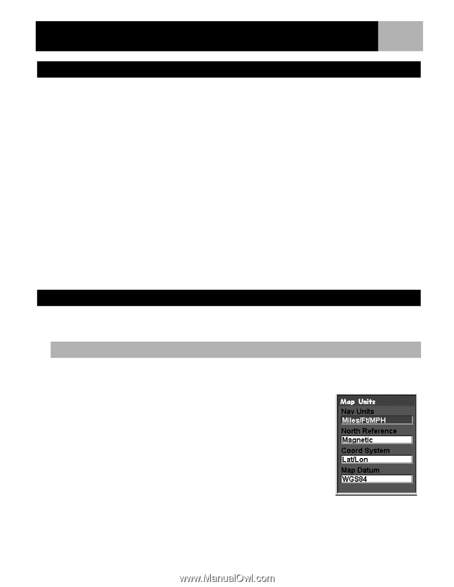
Preferences 81 Selecting the Background or Detail Map The eXplorist comes with a basemap already installed but you may use MapSend Worldwide software (purchased separately) to define your own basemap. You can use Active Setup to select the background map you want to use if you have stored a new one. Also, you can use one of the other MapSend software packages to define and save detailed maps to your eXplorist. These detailed maps can provide more detailed street information, additional POIs, and if using on of the MapSend topographic software packages, topo details. You can use Active Setup to select the detail map you want to use if you have one saved. 1. Press MENU. 2. Use the Arrow joystick to highlight Preferences. 3. Press ENTER. 4. Use the Arrow joystick to highlight Active Setup. 5. Press ENTER. 6. Use the Arrow joystick to highlight the Background Maps or Detail Maps field. 7. Press ENTER. 8. Use the Arrow joystick to highlight the desired map. Note: If you select Detail Map, you have the option of Select Map or Detail Map Off. If you want to not use or do not have a detail map saved, select Detail Map Off and press ENTER. 9. Press ENTER. Setting the Map Units In the Map Units option of Preferences you can select which units of measure for navigation data, the north reference, the coordinate system and the map datum that will be used by the eXplorist. Selecting Navigational Units of Measure The eXplorist can be set to display navigation data in Miles/Yd/MPH, Miles/Ft/MPH, NM/Ft/Knots, NM/M/ Knots or KM/KPH. 1. Press MENU. 2. Use the Arrow joystick to highlight Preferences. 3. Press ENTER. 4. Use the Arrow joystick to highlight Map Units. 5. Press ENTER. 6. Use the Arrow joystick to highlight the data field for Nav Units. 7. Press ENTER. 8. Use the Arrow joystick to highlight the desired navigational units of measure. 9. Press ENTER. The Map Units screen is displayed with the new Nav Units shown. You can change other settings or press ESC to return to the Preferences menu.
-
 1
1 -
2
-
3
-
4
-
5
-
6
-
7
-
8
-
9
-
10
-
11
-
12
-
13
-
14
-
15
-
16
-
17
-
18
-
19
-
20
-
21
-
22
-
23
-
24
-
25
-
26
-
27
-
28
-
29
-
30
-
31
-
32
-
33
-
34
-
35
-
36
-
37
-
38
-
39
-
40
-
41
-
42
-
43
-
44
-
45
-
46
-
47
-
48
-
49
-
50
-
51
-
52
-
53
-
54
-
55
-
56
-
57
-
58
-
59
-
60
-
61
-
62
-
63
-
64
-
65
-
66
-
67
-
68
-
69
-
70
-
71
-
72
-
73
-
74
-
75
-
76
-
77
-
78
-
 79
79 -
 80
80 -
 81
81 -
 82
82 -
 83
83 -
 84
84 -
 85
85 -
 86
86 -
 87
87 -
 88
88 -
 89
89 -
90
-
91
-
92
-
93
-
94
-
95
-
96
-
97
-
98
 |
 |