Nokia 002L5G7 User Guide - Page 95
Position requests, Landmarks, Chg. view, Accept, Reject, Applications, Location, Options
 |
View all Nokia 002L5G7 manuals
Add to My Manuals
Save this manual to your list of manuals |
Page 95 highlights
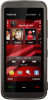
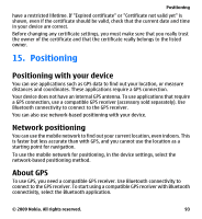
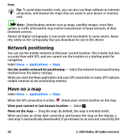
Positioning To view the positions of found satellites, select Chg. view. Initially, the GPS receiver must receive signals from at least four satellites to be able to calculate your location. When the initial calculation has been made, it may be possible to continue calculating your location with three satellites. However, the accuracy is generally better when more satellites are found. If no satellite signal can be found, consider the following: ● If you are indoors, go outdoors to receive a better signal. ● If you are outdoors, move to a more open space. ● If the weather conditions are bad, the signal strength may be affected. ● Some vehicles have tinted (athermic) windows, which may block the satellite signals. Position requests You may receive a request from a network service to receive your position information. Service providers may offer information about local topics, such as weather or traffic conditions, based on the location of your device. When you receive a position request, the service that is making the request is displayed. Select Accept to allow your position information to be sent or Reject to deny the request. Landmarks Select Menu > Applications > Location and Landmarks. With Landmarks, you can save the position information of specific locations in your device. You can sort the saved locations into different categories, such as business, and add other information to them, such as addresses. You can use your saved landmarks in compatible applications, such as GPS data. GPS coordinates are expressed in the degrees and decimal degrees format using the international WGS-84 coordinate system. Select Options and from the following: © 2009 Nokia. All rights reserved. 95
-
 1
1 -
2
-
3
-
4
-
5
-
6
-
7
-
8
-
9
-
10
-
11
-
12
-
13
-
14
-
15
-
16
-
17
-
18
-
19
-
20
-
21
-
22
-
23
-
24
-
25
-
26
-
27
-
28
-
29
-
30
-
31
-
32
-
33
-
34
-
35
-
36
-
37
-
38
-
39
-
40
-
41
-
42
-
43
-
44
-
45
-
46
-
47
-
48
-
49
-
50
-
51
-
52
-
53
-
54
-
55
-
56
-
57
-
58
-
59
-
60
-
61
-
62
-
63
-
64
-
65
-
66
-
67
-
68
-
69
-
70
-
71
-
72
-
73
-
74
-
75
-
76
-
77
-
78
-
79
-
80
-
81
-
82
-
83
-
84
-
85
-
86
-
87
-
88
-
89
-
 90
90 -
 91
91 -
 92
92 -
 93
93 -
 94
94 -
 95
95 -
 96
96 -
 97
97 -
 98
98 -
 99
99 -
 100
100 -
101
-
102
-
103
-
104
-
105
-
106
-
107
-
108
-
109
-
110
-
111
-
112
-
113
-
114
-
115
-
116
-
117
-
118
-
119
-
120
-
121
-
122
-
123
-
124
-
125
-
126
-
127
-
128
-
129
-
130
-
131
-
132
-
133
-
134
-
135
-
136
-
137
-
138
-
139
-
140
-
141
-
142
-
143
-
144
-
145
-
146
-
147
-
148
-
149
-
150
-
151
-
152
-
153
-
154
-
155
-
156
-
157
-
158
-
159
 |
 |
