Nokia 500 User Guide - Page 30
Functions available in navigation screen, Navigate to an address, Alt. route, Waylist, Volume
 |
View all Nokia 500 manuals
Add to My Manuals
Save this manual to your list of manuals |
Page 30 highlights
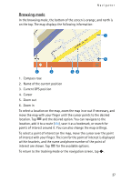
Navigator For one-way streets, the allowed direction is indicated with a blue arrow. To browse the map, tap it. To stop the navigation, tap . Functions available in navigation screen To use the functions available during navigation, tap . You can do the following: • To block the calculated route for the desired distance and force an alternative route, tap Alt. route. • To view the manoeuvres along your route as a waypoint list, tap Waylist. • To save your current position as a bookmark, tap Save. See also "Bookmarks," p. 32. • To mute or set the volume for voice instructions, tap Volume. • To view a list of relevant traffic incidents, tap Traffic info. See also "Traffic information (TMC)," p. 34. • To search for a point of interest, tap Search. See also "Navigate to a point of interest," p. 31. • To adjust some navigation settings, tap Settings (see "Navigation settings," p. 34). To switch from the map view to the icon-based view, tap Map settings > Map (Arrows is displayed). When Arrows is active, the navigation screen displays a big next turn icon, distance to the destination, and a progress bar that indicates the distance to the next turn. • To turn the speed limit warner on or off, tap Start or Stop. Navigate to an address To search for an address to which you want to navigate, press the menu key, and tap Navigator > Destination > Address. To select the country, city (or postal code), street, and house number (optional), tap the fields one by one, and enter the information in this order using the displayed keypad. 30
-
 1
1 -
2
-
3
-
4
-
5
-
6
-
7
-
8
-
9
-
10
-
11
-
12
-
13
-
14
-
15
-
16
-
17
-
18
-
19
-
20
-
21
-
22
-
23
-
24
-
 25
25 -
 26
26 -
 27
27 -
 28
28 -
 29
29 -
 30
30 -
 31
31 -
 32
32 -
 33
33 -
 34
34 -
 35
35 -
36
-
37
-
38
-
39
-
40
-
41
-
42
-
43
-
44
-
45
-
46
-
47
-
48
-
49
-
50
-
51
 |
 |
