Garmin G600 Pilots Guide - Page 115
Flight Plan s
 |
View all Garmin G600 manuals
Add to My Manuals
Save this manual to your list of manuals |
Page 115 highlights
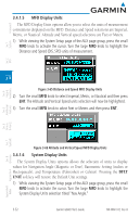
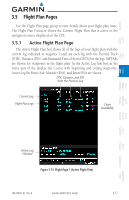
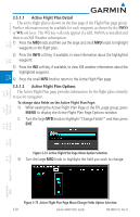
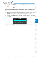
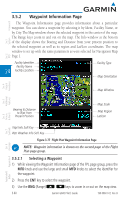
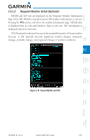
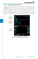
Foreword Sec 1 System Sec 2 PFD 3.5 Flight Plan Pages Use the Flight Plan page group to view details about your flight plan route. The Flight Plan Function shows the Current Flight Plan that is active in the navigation source displayed on the CDI. 3.5.1 Active Flight Plan Page The Active Flight Plan box shows all of the legs of your flight plan with the current leg indicated in magenta. Listed are each leg with the Desired Track (DTK), Distance (DIS), and Estimated Time of Arrival (ETA) for the legs. METARs are shown for waypoints in the flight plan. In the Active Leg Info box in the lower part of the display, the Course with beginning and ending waypoints, Active Leg En Route Safe Altitude (ESA), and Route ESA are shown. DTK, Distance, and ETA from the Previous Leg Current Leg Flight Plan Legs Chart Availability Sec 3 MFD Sec 4 Hazard Avoidance Features Sec 5 Additional Sec 6 Annun. & Alerts Sec 7 Symbols Sec 8 Glossary Appendix A Appendix B Active Leg Window Figure 3-73 Flight Page 1 (Active Flight Plan) 190-00601-02 Rev. B Garmin G600 Pilot's Guide 3-57 Index
-
 1
1 -
2
-
3
-
4
-
5
-
6
-
7
-
8
-
9
-
10
-
11
-
12
-
13
-
14
-
15
-
16
-
17
-
18
-
19
-
20
-
21
-
22
-
23
-
24
-
25
-
26
-
27
-
28
-
29
-
30
-
31
-
32
-
33
-
34
-
35
-
36
-
37
-
38
-
39
-
40
-
41
-
42
-
43
-
44
-
45
-
46
-
47
-
48
-
49
-
50
-
51
-
52
-
53
-
54
-
55
-
56
-
57
-
58
-
59
-
60
-
61
-
62
-
63
-
64
-
65
-
66
-
67
-
68
-
69
-
70
-
71
-
72
-
73
-
74
-
75
-
76
-
77
-
78
-
79
-
80
-
81
-
82
-
83
-
84
-
85
-
86
-
87
-
88
-
89
-
90
-
91
-
92
-
93
-
94
-
95
-
96
-
97
-
98
-
99
-
100
-
101
-
102
-
103
-
104
-
105
-
106
-
107
-
108
-
109
-
 110
110 -
 111
111 -
 112
112 -
 113
113 -
 114
114 -
 115
115 -
 116
116 -
 117
117 -
 118
118 -
 119
119 -
 120
120 -
121
-
122
-
123
-
124
-
125
-
126
-
127
-
128
-
129
-
130
-
131
-
132
-
133
-
134
-
135
-
136
-
137
-
138
-
139
-
140
-
141
-
142
-
143
-
144
-
145
-
146
-
147
-
148
-
149
-
150
-
151
-
152
-
153
-
154
-
155
-
156
-
157
-
158
-
159
-
160
-
161
-
162
-
163
-
164
-
165
-
166
-
167
-
168
-
169
-
170
-
171
-
172
-
173
-
174
-
175
-
176
-
177
-
178
-
179
-
180
-
181
-
182
-
183
-
184
-
185
-
186
-
187
-
188
-
189
-
190
-
191
-
192
-
193
-
194
-
195
-
196
-
197
-
198
-
199
-
200
-
201
-
202
-
203
-
204
-
205
-
206
-
207
-
208
-
209
-
210
-
211
-
212
-
213
-
214
-
215
-
216
-
217
-
218
-
219
-
220
-
221
-
222
-
223
-
224
-
225
-
226
-
227
-
228
-
229
-
230
-
231
-
232
-
233
-
234
-
235
-
236
-
237
-
238
-
239
-
240
 |
 |