Garmin GPS 18 nRoute Printable Help Contents - Page 30
Setting Display Preferences
 |
UPC - 753759042660
View all Garmin GPS 18 manuals
Add to My Manuals
Save this manual to your list of manuals |
Page 30 highlights
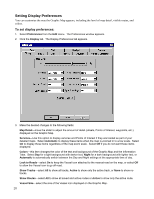
Setting Display Preferences You can customize the way the Graphic Map appears, including the level of map detail, visible routes, and colors. To set display preferences: 1. Select Preferences from the Edit menu. The Preferences window appears. 2. Click the Display tab. The Display Preferences tab appears. 3. Make the desired changes to the following fields: Map Detail-move the slider to adjust the amount of detail (streets, Points of Interest, waypoints, etc.) displayed on the Graphic Map. Services-Use this option to display services and Points of Interest if they are loaded as part of your detailed maps. Select Automatic to display these items when the map is zoomed in to a low scale. Select On to display these items regardless of the map zoom scale. Select Off if you do not want these items displayed. Colors-this item changes the color of the text and background of the Graphic Map and the Information Tabs. Select Day for a light background with darker text, Night for a dark background with lighter text, or Automatic to automatically switch between the Day and Night settings at the appropriate time of day. Lock to Roads-select On to keep the Vessel icon attached to the nearest road on the map, or select Off to allow the Vessel icon to go off-road. Show Tracks-select All to show all tracks, Active to show only the active track, or None to show no tracks. Show Routes-select All to show all saved and active routes or Active to show only the active route. Vessel Size-select the size of the Vessel icon displayed on the Graphic Map. 28
-
 1
1 -
2
-
3
-
4
-
5
-
6
-
7
-
8
-
9
-
10
-
11
-
12
-
13
-
14
-
15
-
16
-
17
-
18
-
19
-
20
-
21
-
22
-
23
-
24
-
 25
25 -
 26
26 -
 27
27 -
 28
28 -
 29
29 -
 30
30 -
 31
31 -
 32
32 -
 33
33 -
 34
34 -
 35
35 -
36
-
37
-
38
-
39
-
40
-
41
-
42
-
43
-
44
-
45
-
46
-
47
-
48
-
49
-
50
-
51
-
52
-
53
-
54
-
55
-
56
-
57
-
58
-
59
-
60
-
61
-
62
-
63
-
64
-
65
-
66
-
67
-
68
-
69
-
70
-
71
-
72
-
73
-
74
-
75
-
76
-
77
-
78
-
79
-
80
-
81
-
82
-
83
-
84
-
85
-
86
-
87
-
88
-
89
-
90
-
91
-
92
-
93
-
94
-
95
-
96
-
97
-
98
-
99
-
100
-
101
-
102
-
103
-
104
-
105
-
106
-
107
-
108
-
109
-
110
-
111
-
112
-
113
-
114
-
115
-
116
-
117
-
118
-
119
-
120
-
121
-
122
-
123
-
124
-
125
-
126
-
127
-
128
-
129
-
130
 |
 |
