Garmin GPSMAP 546/546s Owner's Manual - Page 25
Using Fishing Charts, Enabling High Resolution Satellite Imagery, Charts, Fishing Chart
 |
View all Garmin GPSMAP 546/546s manuals
Add to My Manuals
Save this manual to your list of manuals |
Page 25 highlights
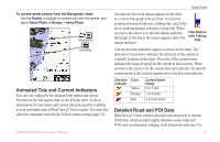
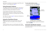
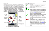
Using Fishing Charts Use the Fishing chart for a detailed, unobstructed view of the bottom contours on the chart. The Fishing chart uses detailed bathymetric data, and is best for offshore deep-sea fishing. From the Home screen, select Charts > Fishing Chart. Using Charts Navaids-displays navigational aids, such as beacons, lights, and obstructions. For settings and options related to Full Screen Map, Waypoints & Tracks, Other Vessels, and Data Bars, see "Navigation Chart Menu" on page 9. To customize the appearance of the Fishing Chart screen, select MENU > Chart Setup (page 12). Enabling High Resolution Satellite Imagery You can overlay high-resolution satellite images on the land, sea, or both portions of the Navigation chart when using a preprogrammed BlueChart g2 Vision SD card. To access additional settings from the Fishing chart, press MENU. To enable satellite imagery: 1. While viewing the Navigation chart, press MENU. 2. Select Chart Setup > Photos. 3. Select one of the following: • Off-standard chart information is shown on the map. • Land Only-standard chart information is shown on water with photos overlaying the land. • On-photos overlay both the water and the land at a specified opacity. Use the right and left arrows on the Rocker to adjust the opacity. The higher you set the percentage, the more the satellite photos will cover both land and water. GPSMAP 400/500 Series Owner's Manual 19
-
 1
1 -
2
-
3
-
4
-
5
-
6
-
7
-
8
-
9
-
10
-
11
-
12
-
13
-
14
-
15
-
16
-
17
-
18
-
19
-
 20
20 -
 21
21 -
 22
22 -
 23
23 -
 24
24 -
 25
25 -
 26
26 -
 27
27 -
 28
28 -
 29
29 -
 30
30 -
31
-
32
-
33
-
34
-
35
-
36
-
37
-
38
-
39
-
40
-
41
-
42
-
43
-
44
-
45
-
46
-
47
-
48
-
49
-
50
-
51
-
52
-
53
-
54
-
55
-
56
-
57
-
58
-
59
-
60
-
61
-
62
-
63
-
64
-
65
-
66
-
67
-
68
-
69
-
70
-
71
-
72
-
73
-
74
-
75
-
76
-
77
-
78
-
79
-
80
-
81
-
82
-
83
-
84
-
85
-
86
-
87
-
88
-
89
-
90
-
91
-
92
-
93
-
94
-
95
-
96
 |
 |
