Garmin GTN 650 STC GTN 6XX/7XX AFMS - Page 3
Weight And Balance - manual
 |
View all Garmin GTN 650 manuals
Add to My Manuals
Save this manual to your list of manuals |
Page 3 highlights
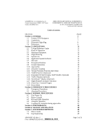
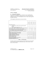
GARMIN Ltd. or its Subsidiaries, c/o Garmin International 1200 E. 151st Street Olathe, KS 66062 USA AIRPLANE FLIGHT MANUAL SUPPLEMENT or SUPPLEMENTAL AIRPLANE FLIGHT MANUAL for STC SA02019SE-D GARMIN GTN NAVIGATION SYSTEM Table of Contents SECTION Section 1. GENERAL 1.1 Garmin GTN Navigators 1.2 Capabilities 1.3 Electronic Flight Bag 1.4 Definitions Section 2. LIMITATIONS 2.1 Cockpit Reference Guide 2.2 Kinds of Operation 2.3 Minimum Equipment 2.4 Flight Planning 2.5 System Use 2.6 Applicable System Software 2.7 SD Card 2.8 Navigation Database 2.9 Ground Operations 2.10 Approaches 2.11 Autopilot Coupling 2.12 Terrain Proximity Function (All Units) 2.13 TAWS Function (Optional) 2.14 Datalinked Weather Display (XM Weather, Optional) 2.15 Traffic Display (Optional) 2.16 StormScope® Display (Optional) 2.17 Flight Planner/Calculator Functions 2.18 Glove Use / Covered Fingers 2.19 Demo Mode Section 3. EMERGENCY PROCEDURES 3.1 Emergency Procedures 3.2 Abnormal Procedures Section 4. NORMAL PROCEDURES 4.1 Unit Power On 4.2 Before Takeoff 4.3 HSI and EHSI Operation 4.4 Autopilot Operation 4.5 Coupling the Autopilot during approaches Section 5. PERFORMANCE Section 6. WEIGHT AND BALANCE Section 7. SYSTEM DESCRIPTIONS 7.1 Pilot's Guide 7.2 Leg Sequencing PAGE 5 5 7 8 9 11 11 11 12 13 14 15 15 15 16 16 17 17 17 18 18 18 18 18 19 20 20 21 25 25 25 25 26 27 28 28 28 28 28 190-01007-A2 Rev. 1 FAA APPROVED DATE: _M__A_R_C_H__1_8__,_2_0_1_1__ Page 3 of 31
-
 1
1 -
 2
2 -
 3
3 -
 4
4 -
 5
5 -
 6
6 -
 7
7 -
 8
8 -
 9
9 -
10
-
11
-
12
-
13
-
14
-
15
-
16
-
17
-
18
-
19
-
20
-
21
-
22
-
23
-
24
-
25
-
26
-
27
-
28
-
29
-
30
-
31
 |
 |
