Garmin aera 795 Pilot's Guide - Page 103
Freezing Levels, Turbulence Forecast
 |
View all Garmin aera 795 manuals
Add to My Manuals
Save this manual to your list of manuals |
Page 103 highlights
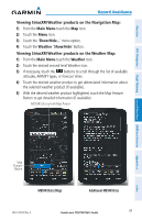
Overview GPS Navigation Hazard Avoidance FREEZING LEVELS Freezing Level shows contours for the lowest forecast altitude where icing conditions are likely to occur. Freezing Level Data TURBULENCE FORECAST Turbulence data identifies the potential for erratic movement of high-altitude air mass associated winds. Turbulence is classified as light, moderate, severe, or extreme. Turbulence data is intended to supplement AIRMETs and SIGMETs. Turbulence Forecast Legend Light Turbulence Selected Flight Planning Hazard Avoidance Additional Features Appendices Index 190-01194-00 Rev. A Garmin aera 795/796 Pilot's Guide 89
-
 1
1 -
2
-
3
-
4
-
5
-
6
-
7
-
8
-
9
-
10
-
11
-
12
-
13
-
14
-
15
-
16
-
17
-
18
-
19
-
20
-
21
-
22
-
23
-
24
-
25
-
26
-
27
-
28
-
29
-
30
-
31
-
32
-
33
-
34
-
35
-
36
-
37
-
38
-
39
-
40
-
41
-
42
-
43
-
44
-
45
-
46
-
47
-
48
-
49
-
50
-
51
-
52
-
53
-
54
-
55
-
56
-
57
-
58
-
59
-
60
-
61
-
62
-
63
-
64
-
65
-
66
-
67
-
68
-
69
-
70
-
71
-
72
-
73
-
74
-
75
-
76
-
77
-
78
-
79
-
80
-
81
-
82
-
83
-
84
-
85
-
86
-
87
-
88
-
89
-
90
-
91
-
92
-
93
-
94
-
95
-
96
-
97
-
 98
98 -
 99
99 -
 100
100 -
 101
101 -
 102
102 -
 103
103 -
 104
104 -
 105
105 -
 106
106 -
 107
107 -
 108
108 -
109
-
110
-
111
-
112
-
113
-
114
-
115
-
116
-
117
-
118
-
119
-
120
-
121
-
122
-
123
-
124
-
125
-
126
-
127
-
128
-
129
-
130
-
131
-
132
-
133
-
134
-
135
-
136
-
137
-
138
-
139
-
140
-
141
-
142
-
143
-
144
-
145
-
146
-
147
-
148
-
149
-
150
-
151
-
152
-
153
-
154
-
155
-
156
-
157
-
158
-
159
-
160
-
161
-
162
-
163
-
164
-
165
-
166
-
167
-
168
-
169
-
170
-
171
-
172
-
173
-
174
-
175
-
176
-
177
-
178
-
179
-
180
-
181
-
182
-
183
-
184
-
185
-
186
-
187
-
188
-
189
-
190
-
191
-
192
-
193
-
194
-
195
-
196
-
197
-
198
-
199
-
200
-
201
-
202
-
203
-
204
-
205
-
206
-
207
-
208
-
209
-
210
 |
 |

Garmin aera 795/796 Pilot’s Guide
190-01194-00 Rev. A
89
Hazard Avoidance
Overview
GPS Navigation
Flight Planning
Hazard Avoidance
Additional Features
Appendices
Index
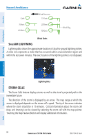
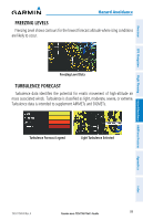
FREEZING LEVELS
Freezing Level shows contours for the lowest forecast altitude where icing conditions
are likely to occur.
Freezing Level Data
TURBULENCE FORECAST
Turbulence data identifies the potential for erratic movement of high-altitude air
mass associated winds.
Turbulence is classified as light, moderate, severe, or extreme.
Turbulence data is intended to supplement AIRMETs and SIGMETs.
Turbulence Forecast Legend
Light Turbulence Selected