Garmin dezl OTR700/800/1000 Owners Manual - Page 17
Map Tools, Up Ahead, Cities Ahead, Warning and Alert Symbols
 |
View all Garmin dezl OTR700/800/1000 manuals
Add to My Manuals
Save this manual to your list of manuals |
Page 17 highlights
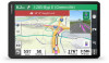
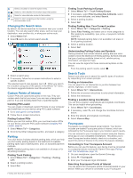
Deleting a Saved Location NOTE: Deleted locations cannot be recovered. 1 Select Where To? > Saved. 2 Select > Delete Saved Places. 3 Select the box next to the saved locations to delete, and select Delete. Using the Map You can use the map to navigate a route (Your Route on the Map, page 5) or to view a map of your surroundings when no route is active. 1 Select View Map. 2 Touch anywhere on the map. 3 Select an option: • Drag the map to pan left, right, up, or down. • To zoom in or out, select or . • To switch between North Up and 3-D views, select . • To start a route, select a location on the map, and select Go! (Starting a Route by Using the Map, page 5). Map Tools Map tools provide quick access to information and device functions while you view the map. When you activate a map tool, it appears in a panel at the edge of the map. Stop: Stops navigation of the active route. Edit Route: Allows you to take a detour or skip locations in your route (Changing Your Active Route, page 6). Mute: Mutes the device audio. Cities Ahead: Shows upcoming cities and services along your active route or along a highway (Cities Ahead, page 11). Up Ahead: Shows upcoming locations along the route or the road on which you are traveling (Up Ahead, page 11). Elevation: Displays elevation changes ahead. Traffic: Displays traffic conditions along your route or in your area (Viewing Upcoming Traffic, page 12). This feature is not available in all areas or for all device models. Trip Data: Displays customizable trip data, such as speed or mileage (Viewing Trip Data from the Map, page 12). Turns: Displays a list of upcoming turns in your route (Viewing Turns and Directions, page 5). Phone: Displays a list of recent phone calls from your connected phone, and displays in-call options while a phone call is active (Using In-Call Options, page 13). Weather: Displays weather conditions for your area. photoLive: Displays live traffic cameras from your photoLive subscription (photoLive Traffic Cameras, page 14). Report Camera: Allows you to report a speed or red light camera. This tool is available only when you have speed or red light camera data on your device and you have an active connection to the Garmin Drive app. Garmin eLog: Displays hours of service information from the Garmin eLog™ app. Allows you to change duty status while you are not driving. Viewing a Map Tool 1 From the map, select . 2 Select a map tool. The map tool appears in a panel at the edge of the map. 3 When you are done using the map tool, select . Up Ahead The Up Ahead tool provides information about upcoming locations along your route or the road on which you are traveling. You can view upcoming points of interest by category, such as restaurants, fuel stations, or rest areas. You can customize the categories that show in the Up Ahead tool. Viewing Upcoming Locations 1 From the map, select > Up Ahead. While you are traveling, the map tool shows the next location along your road or route. 2 Select an option: • If the map tool shows categories, select a category to view a list of nearby locations in that category. • If the map tool shows upcoming locations, select a location to view location details or start a route to the location. Customizing the Up Ahead Categories You can change the location categories that appear in the Up Ahead tool. 1 From the map, select > Up Ahead. 2 Select a category. 3 Select . 4 Select an option: • To move a category up or down in the list, select and drag the arrow next to the category name. • To change a category, select the category. • To create a custom category, select a category, select Custom Search, and enter the name of a business or category. 5 Select Save. Cities Ahead While you are traveling on a highway or navigating a route that includes a highway, the Cities Ahead tool provides information about upcoming cities along the highway. For each city, the map tool shows the distance to the highway exit and the services available, similar to the information on highway road signs. Viewing Upcoming Cities and Exit Services 1 From the map, select > Cities Ahead. While you are traveling along a highway or an active route, the map tool shows information about upcoming cities and exits. 2 Select a city. The device shows a list of points of interest located at the selected city exit, such as fuel stations, lodging, or restaurants. 3 Select a location, and select Go! to start navigating. Warning and Alert Symbols WARNING Entering your vehicle profile characteristics does not guarantee that your vehicle's characteristics will be accounted for in all route suggestions or that you will receive the warning icons in all cases. Limitations may exist in the map data such that your device cannot account for these restrictions or road conditions in all cases. Always defer to all posted road signs and road conditions when making driving decisions. Warning and alert symbols may appear on the map or in route directions to alert you to potential hazards, road conditions, and upcoming weigh stations. Using the Map 11
-
 1
1 -
2
-
3
-
4
-
5
-
6
-
7
-
8
-
9
-
10
-
11
-
 12
12 -
 13
13 -
 14
14 -
 15
15 -
 16
16 -
 17
17 -
 18
18 -
 19
19 -
 20
20 -
 21
21 -
 22
22 -
23
-
24
-
25
-
26
-
27
-
28
-
29
-
30
-
31
-
32
-
33
-
34
-
35
-
36
 |
 |
