Icom ID-52A D-star Using The Gps Logger Function - Page 6
Viewing the log data on a PC Map, free map software.
 |
View all Icom ID-52A manuals
Add to My Manuals
Save this manual to your list of manuals |
Page 6 highlights
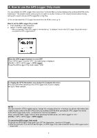
5. Viewing the log data on a PC Map You can download log information to a PC and check it. LLWindows 10 is used for these instructions. 1. Turn OFF the transceiver, and then remove the microSD card. LLTo remove the card while the transceiver is ON, unmount it first. (See the transceiver's manual.) 2. Insert a microSD card into the SD card slot of the PC or the memory card reader connected to the PC. 3. Click the "Open folder to view files" option to access the card. TIP: You can display your route on Google Earth (free map software). 1. Select "GPS" in the "Tools" menu of Google Earth. 2. Check "Import from file" in the "GPS Import" screen, and then click "Import." 3. Select the log file displayed in step 4 on the left. •• The log is displayed on the map, as shown below. Click LLThe folder with the name of your transceiver is displayed. 4. Double-click the "ID-52" (example) folder. Click 5. Double-click the "Gps" folder. ©Google The screen that the log file is displayed in Google Earth. LLYou can display the logged altitude information by right- clicking on the displayed log, and then select "Show Elevation Profile." Click The log files are saved here. •• The log files are displayed. LLThe files are named with the time the log was started, in the following format: yyyymmdd_hhmmss.log (yyyy: Year, mm: month, dd: day, hh: hour, mm: minute, ss: second). LLYou can see your route on the software map by importing the selected log. LLThe file may not be compatible with all mapping software. 6
-
 1
1 -
 2
2 -
 3
3 -
 4
4 -
 5
5 -
 6
6 -
 7
7 -
 8
8
 |
 |
