Jensen MS4200RS User Manual - Page 13
The digital road map 210, GENERAL INFORMATION
 |
View all Jensen MS4200RS manuals
Add to My Manuals
Save this manual to your list of manuals |
Page 13 highlights
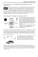
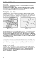
GENERAL INFORMATION Comments After transport of the vehicle by train or ferry, the navigation system may require a few minutes for exact positioning. After disconnecting the vehicle battery, up to 15 minutes may be required for exact positioning. For this, the vehicle must be outdoors and the system must be switched on in order to receive transmissions from the GPS satellites. The digital road map To be able to plan a route to a destination address, the navigation system not only requires the current position of the vehicle but also a digital road map containing the destination address itself and the roads leading to the destination address. This digital road map is on the map CD which you insert into the navigation computer. Real road network Digital line model The road system is stored on the map CD as a line model, i.e. even large intersections have only one focal point that is approached by all roads in point-to-point fashion. Thus the navigation system indicates the distance to the turn-off point as the distance to the center of the intersection. This is why the distances indicated on main road signs may not agree with those of the navigation system. The road signs indicate the distance to the beginning of the exit. Areas with limited road information In some areas, not all of the information on a road is available on the map CD. Thus, for example, turn-off prohibitions, information on the direction of travel in a one-way street or prohibited entry into a pedestrian zone may be missing. The navigation system will display a warning if you drive into such an area. Local traffic laws always take precedence over navigation system instructions. Always observe the road signs and motor vehicle traffic regulations. Topicality of the map CD Roughly 10 - 15% of the road system characteristics change each year. Due to these constantly changing traffic conditions (construction of new roads, traffic calming, etc.) we cannot guarantee that the digital road map will be in 100 % agreement with existing traffic conditions. We recommend that you always use the most current version of the map CD for navigation. 10
-
 1
1 -
2
-
3
-
4
-
5
-
6
-
7
-
 8
8 -
 9
9 -
 10
10 -
 11
11 -
 12
12 -
 13
13 -
 14
14 -
 15
15 -
 16
16 -
 17
17 -
 18
18 -
19
-
20
-
21
-
22
-
23
-
24
-
25
-
26
-
27
-
28
-
29
-
30
-
31
-
32
-
33
-
34
-
35
-
36
-
37
-
38
-
39
-
40
-
41
-
42
-
43
-
44
-
45
-
46
-
47
-
48
-
49
-
50
-
51
-
52
-
53
-
54
-
55
-
56
-
57
-
58
-
59
-
60
-
61
-
62
-
63
-
64
-
65
 |
 |
