Uniden UM415 English Owners Manual - Page 36
Connec°ng to a Chartplo´er
 |
UPC - 050633501290
View all Uniden UM415 manuals
Add to My Manuals
Save this manual to your list of manuals |
Page 36 highlights
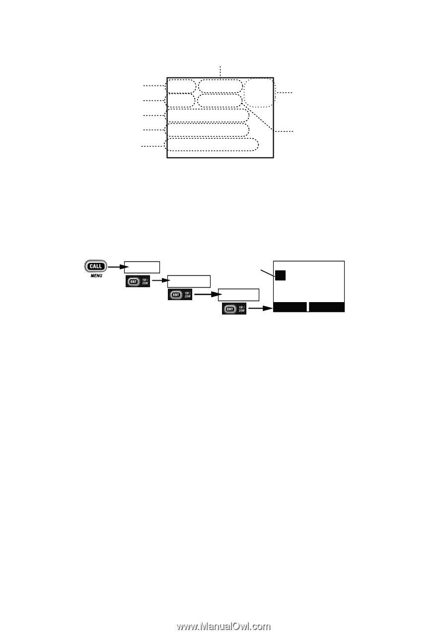
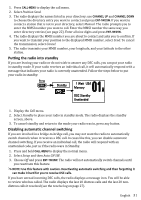
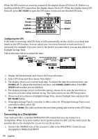
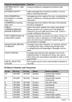
When the GPS receiver is correctly connected, the display shows GPS Data OK. If there is a problem with the GPS connection, the display shows Check GPS. When the display shows GPS Data OK, press ENT-1W/25W to open the GPS status screen and see detailed GPS data: Time Date Course Latitude Longitude Status 16 06/20 11:00:00 208o 30. 0 KT 35o 40. 610 N 139o 46. 564 E GPS Data: External Current channel Speed Configuring the GPS If the radio is receiving valid GPS data, it will automatically set the clock to your local time based on the GPS location. You can adjust your local time forward or back one hour if necessary (for example, if you are close to the border of a time zone); you can also adjust for Daylight Savings Time. Follow the steps below to adjust the time: Press and hold - Setup Use the up and down arrows to adjust the time by GPS Setup one hour. 16 Time Adjust 09 : 14 Time Adjust Back[CLR] Select[ENT] 1. Display the normal menu and choose the Setup sub-menu. 2. Select GPS Setup and then choose Time Adjust. 3. The display shows your current local time. To adjust the time forward one hour, use CHANNEL UP. To adjust the time back one hour, use CHANNEL DOWN button. Press ENT1W/25W button when you are finished. 4. The display prompts you to confirm the setting: choose Set to save the new time or Cancel to exit time setup without saving. The radio returns to the GPS Setup menu. 5. If your local area observes Daylight Savings Time, choose Daylight Save and press the ENT-1W/25W button. 6. If Daylight Savings Time is currently in effect, select On. If Daylight Savings Time is not currently in effect, select Off. 7. Press ENT-1W/25W. The radio activates the new time setting and returns to the GPS Setup menu. Connecting to a Chartplotter Your radio provides a standard NMEA0183 GPS output that you can connect to a chartplotter. When it receives another boat's position data in a DSC call, the radio sends the position data to the chartplotter so you can see the location: 1. Connect the ORANGE wire of the accessory cable to the NEGATIVE (-) wire of your chartplotter's NMEA data INPUT. 36 English
-
 1
1 -
2
-
3
-
4
-
5
-
6
-
7
-
8
-
9
-
10
-
11
-
12
-
13
-
14
-
15
-
16
-
17
-
18
-
19
-
20
-
21
-
22
-
23
-
24
-
25
-
26
-
27
-
28
-
29
-
30
-
 31
31 -
 32
32 -
 33
33 -
 34
34 -
 35
35 -
 36
36 -
 37
37 -
 38
38 -
 39
39 -
 40
40 -
 41
41 -
42
-
43
-
44
-
45
-
46
-
47
-
48
-
49
-
50
-
51
-
52
-
53
 |
 |